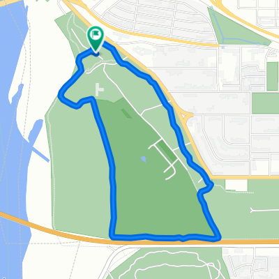
Docs, Crocs, Scholars and Frocks: Walkers Route
A cycling route starting in Bismarck, North Dakota, United States of America.
Overview
About this route
Walkers Your host is LeNita Bello
Your route will begin at the capitol. From the capitol, walk to Boulevard Avenue and over to Washington Street where you will get on the Tom O’Leary walking trail. You will walk north to Washington Street, then west on Divide, then south on Ward Road, then in front of the tennis courts, north into the McQuade softball diamond, and north again to Good Shepherd Lutheran Church, located on the corner of Divide Avenue and Washington Street. Rides will be available at end of your walk in the Good Shepherd parking lot to transport you back to your vehicles on the capitol grounds. Â- -:--
- Duration
- 5.8 km
- Distance
- 49 m
- Ascent
- 52 m
- Descent
- ---
- Avg. speed
- ---
- Avg. speed
Route quality
Waytypes & surfaces along the route
Waytypes
Road
2.6 km
(45 %)
Pedestrian area
1.8 km
(31 %)
Surfaces
Paved
0.7 km
(13 %)
Asphalt
0.7 km
(13 %)
Undefined
5 km
(87 %)
Continue with Bikemap
Use, edit, or download this cycling route
You would like to ride Docs, Crocs, Scholars and Frocks: Walkers Route or customize it for your own trip? Here is what you can do with this Bikemap route:
Free features
- Save this route as favorite or in collections
- Copy & plan your own version of this route
- Sync your route with Garmin or Wahoo
Premium features
Free trial for 3 days, or one-time payment. More about Bikemap Premium.
- Navigate this route on iOS & Android
- Export a GPX / KML file of this route
- Create your custom printout (try it for free)
- Download this route for offline navigation
Discover more Premium features.
Get Bikemap PremiumFrom our community
Other popular routes starting in Bismarck
- Day 15 Lag 2
- Distance
- 115.1 km
- Ascent
- 313 m
- Descent
- 218 m
- Location
- Bismarck, North Dakota, United States of America
- Devil's Day Ride
- Distance
- 12.2 km
- Ascent
- 104 m
- Descent
- 87 m
- Location
- Bismarck, North Dakota, United States of America
- New Salem Loop
- Distance
- 150.6 km
- Ascent
- 433 m
- Descent
- 430 m
- Location
- Bismarck, North Dakota, United States of America
- 1265–1299 S 12th St, Bismarck to University Dr, Bismarck
- Distance
- 6.6 km
- Ascent
- 13 m
- Descent
- 16 m
- Location
- Bismarck, North Dakota, United States of America
- 229-> BISMARCK - MOTT
- Distance
- 167 km
- Ascent
- 567 m
- Descent
- 363 m
- Location
- Bismarck, North Dakota, United States of America
- My start
- Distance
- 2,161.1 km
- Ascent
- 15,578 m
- Descent
- 15,998 m
- Location
- Bismarck, North Dakota, United States of America
- Riverside Park Road 299, Bismarck to Riverside Park Road 299, Bismarck
- Distance
- 4.5 km
- Ascent
- 7 m
- Descent
- 8 m
- Location
- Bismarck, North Dakota, United States of America
- 320 W Lasalle Dr, Bismarck to 1310 E Main Ave, Bismarck
- Distance
- 8.2 km
- Ascent
- 14 m
- Descent
- 79 m
- Location
- Bismarck, North Dakota, United States of America
Open it in the app