

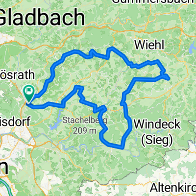
modifizierte Permanente des RTV Lohmar
A cycling route starting in Lohmar, North Rhine-Westphalia, Germany.
Overview
About this route
modified route of the RTV Lohmar Permanente starting at the Jabachhalle
720 meters of elevation gain (measured with HAC)
- -:--
- Duration
- 67.6 km
- Distance
- 549 m
- Ascent
- 549 m
- Descent
- ---
- Avg. speed
- ---
- Max. altitude
Continue with Bikemap
Use, edit, or download this cycling route
You would like to ride modifizierte Permanente des RTV Lohmar or customize it for your own trip? Here is what you can do with this Bikemap route:
Free features
- Save this route as favorite or in collections
- Copy & plan your own version of this route
- Sync your route with Garmin or Wahoo
Premium features
Free trial for 3 days, or one-time payment. More about Bikemap Premium.
- Navigate this route on iOS & Android
- Export a GPX / KML file of this route
- Create your custom printout (try it for free)
- Download this route for offline navigation
Discover more Premium features.
Get Bikemap PremiumFrom our community
Other popular routes starting in Lohmar
 modifizierte Permanente des RTV Lohmar
- Distance
- 67.6 km
- Ascent
- 549 m
- Descent
- 549 m
- Location
- Lohmar, North Rhine-Westphalia, Germany
 Täler und Höhen
- Distance
- 99.6 km
- Ascent
- 865 m
- Descent
- 863 m
- Location
- Lohmar, North Rhine-Westphalia, Germany
 Lohmar - Lindlar - Lohmar
- Distance
- 69.1 km
- Ascent
- 669 m
- Descent
- 668 m
- Location
- Lohmar, North Rhine-Westphalia, Germany
 Wahner Heide 19.01.2019
- Distance
- 10.3 km
- Ascent
- 79 m
- Descent
- 87 m
- Location
- Lohmar, North Rhine-Westphalia, Germany
 Täler und Höhen 111 km
- Distance
- 112.1 km
- Ascent
- 882 m
- Descent
- 882 m
- Location
- Lohmar, North Rhine-Westphalia, Germany
 Täler und Höhen 151
- Distance
- 153.8 km
- Ascent
- 1,051 m
- Descent
- 1,053 m
- Location
- Lohmar, North Rhine-Westphalia, Germany
 Täler und Höhen 45
- Distance
- 48.9 km
- Ascent
- 410 m
- Descent
- 408 m
- Location
- Lohmar, North Rhine-Westphalia, Germany
 Wahnbachtalsperre Albach - Albach gefahren
- Distance
- 28.1 km
- Ascent
- 371 m
- Descent
- 354 m
- Location
- Lohmar, North Rhine-Westphalia, Germany
Open it in the app