

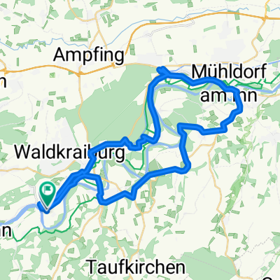
20150805_INN08 MUELH
A cycling route starting in Jettenbach, Bavaria, Germany.
Overview
About this route
TEASI track
- -:--
- Duration
- 19.6 km
- Distance
- 96 m
- Ascent
- 103 m
- Descent
- ---
- Avg. speed
- ---
- Max. altitude

Route quality
Waytypes & surfaces along the route
Waytypes
Quiet road
14.6 km
(74 %)
Road
3.6 km
(18 %)
Surfaces
Paved
17.3 km
(88 %)
Unpaved
1.7 km
(9 %)
Asphalt
17 km
(87 %)
Gravel
1.6 km
(8 %)
Continue with Bikemap
Use, edit, or download this cycling route
You would like to ride 20150805_INN08 MUELH or customize it for your own trip? Here is what you can do with this Bikemap route:
Free features
- Save this route as favorite or in collections
- Copy & plan your own version of this route
- Sync your route with Garmin or Wahoo
Premium features
Free trial for 3 days, or one-time payment. More about Bikemap Premium.
- Navigate this route on iOS & Android
- Export a GPX / KML file of this route
- Create your custom printout (try it for free)
- Download this route for offline navigation
Discover more Premium features.
Get Bikemap PremiumFrom our community
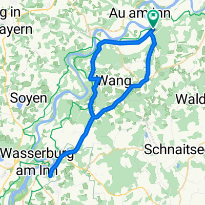
Other popular routes starting in Jettenbach
 jettenbach - schnaitsee (funkturm)
- Distance
- 30.2 km
- Ascent
- 341 m
- Descent
- 340 m
- Location
- Jettenbach, Bavaria, Germany
 aschau werk - heldenstein - ampfing-melle
- Distance
- 26.2 km
- Ascent
- 155 m
- Descent
- 147 m
- Location
- Jettenbach, Bavaria, Germany
 Inn-kanaltour
- Distance
- 39.4 km
- Ascent
- 194 m
- Descent
- 193 m
- Location
- Jettenbach, Bavaria, Germany
 Jettenbach - St. Saturnin
- Distance
- 1,057.1 km
- Ascent
- 3,641 m
- Descent
- 3,545 m
- Location
- Jettenbach, Bavaria, Germany
 babensham
- Distance
- 29.1 km
- Ascent
- 323 m
- Descent
- 324 m
- Location
- Jettenbach, Bavaria, Germany
 Morning Ride 2
- Distance
- 53.6 km
- Ascent
- 394 m
- Descent
- 391 m
- Location
- Jettenbach, Bavaria, Germany
 mittergars - gars (inn) - schambach - oberreith
- Distance
- 23 km
- Ascent
- 285 m
- Descent
- 285 m
- Location
- Jettenbach, Bavaria, Germany
 Wasserburg (über schambach)
- Distance
- 33.8 km
- Ascent
- 309 m
- Descent
- 309 m
- Location
- Jettenbach, Bavaria, Germany
Open it in the app