Frankenfelder Mühle - Grethem - Gilten
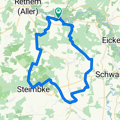
A cycling route starting in Frankenfeld, Lower Saxony, Germany.
Overview
About this route
<p>
Start on Lindenallee by Frankenfeldermühle and go about 3 km straight ahead, then turn left and continue to Eschenwoth towards Eschenworth, there turn left to Mühlenkamp, then turn left onto the main road to Grethem, opposite the village road turn right, then the next one left again, after about 1 km turn left to the main road to Gilten = destination.</p>
Translated, show original (German)- -:--
- Duration
- 14.3 km
- Distance
- 50 m
- Ascent
- 46 m
- Descent
- ---
- Avg. speed
- ---
- Max. altitude
Route quality
Waytypes & surfaces along the route
Waytypes
Track
8.1 km
(57 %)
Quiet road
5.6 km
(39 %)
Undefined
0.6 km
(4 %)
Surfaces
Paved
7.6 km
(53 %)
Unpaved
6.8 km
(48 %)
Asphalt
6.4 km
(45 %)
Ground
4.6 km
(32 %)
Continue with Bikemap
Use, edit, or download this cycling route
You would like to ride Frankenfelder Mühle - Grethem - Gilten or customize it for your own trip? Here is what you can do with this Bikemap route:
Free features
- Save this route as favorite or in collections
- Copy & plan your own version of this route
- Sync your route with Garmin or Wahoo
Premium features
Free trial for 3 days, or one-time payment. More about Bikemap Premium.
- Navigate this route on iOS & Android
- Export a GPX / KML file of this route
- Create your custom printout (try it for free)
- Download this route for offline navigation
Discover more Premium features.
Get Bikemap PremiumFrom our community
Other popular routes starting in Frankenfeld
- Allerhof zum Reiterhof Hagedorn Steimbke
- Distance
- 9.7 km
- Ascent
- 36 m
- Descent
- 31 m
- Location
- Frankenfeld, Lower Saxony, Germany
- Bosse - Verden rechts der Aller
- Distance
- 67.7 km
- Ascent
- 51 m
- Descent
- 49 m
- Location
- Frankenfeld, Lower Saxony, Germany
- Recovered Route
- Distance
- 13.1 km
- Ascent
- 0 m
- Descent
- 3 m
- Location
- Frankenfeld, Lower Saxony, Germany
- Die Wolfstour (Nord-Route)
- Distance
- 47.2 km
- Ascent
- 73 m
- Descent
- 73 m
- Location
- Frankenfeld, Lower Saxony, Germany
- 50Km_Bosse_Lichtenmoor_Frankenfeld
- Distance
- 50.9 km
- Ascent
- 61 m
- Descent
- 62 m
- Location
- Frankenfeld, Lower Saxony, Germany
- Allertal - NRÜ
- Distance
- 57 km
- Ascent
- 76 m
- Descent
- 55 m
- Location
- Frankenfeld, Lower Saxony, Germany
- 50Km_Bosse_Lichtenmoor_Frankenfeld
- Distance
- 50.9 km
- Ascent
- 61 m
- Descent
- 62 m
- Location
- Frankenfeld, Lower Saxony, Germany
- Frankenfeld(Aller) Denkmal nach Am Hohen Ufer 3A
- Distance
- 62.1 km
- Ascent
- 170 m
- Descent
- 135 m
- Location
- Frankenfeld, Lower Saxony, Germany
Open it in the app