

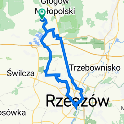
Pociągiem do Bud Głogowskich
A cycling route starting in Głogów Małopolski, Subcarpathian Voivodeship, Poland.
Overview
About this route
pleasant, a lot through the woods, relatively easy
- -:--
- Duration
- 26.8 km
- Distance
- 74 m
- Ascent
- 116 m
- Descent
- ---
- Avg. speed
- ---
- Max. altitude
Route highlights
Points of interest along the route
Point of interest after 5.9 km
Lane piwo po 4,50 w promocji
Point of interest after 21.9 km
Bar Zakopiec interesujący punkt
Continue with Bikemap
Use, edit, or download this cycling route
You would like to ride Pociągiem do Bud Głogowskich or customize it for your own trip? Here is what you can do with this Bikemap route:
Free features
- Save this route as favorite or in collections
- Copy & plan your own version of this route
- Sync your route with Garmin or Wahoo
Premium features
Free trial for 3 days, or one-time payment. More about Bikemap Premium.
- Navigate this route on iOS & Android
- Export a GPX / KML file of this route
- Create your custom printout (try it for free)
- Download this route for offline navigation
Discover more Premium features.
Get Bikemap PremiumFrom our community
Other popular routes starting in Głogów Małopolski
 Zabajka- strefa Dworzysko- rynek Rzeszów- Zabajka
- Distance
- 35.6 km
- Ascent
- 114 m
- Descent
- 116 m
- Location
- Głogów Małopolski, Subcarpathian Voivodeship, Poland
 Zabajka- lotnisko- Zapole- Zabajka
- Distance
- 31.3 km
- Ascent
- 122 m
- Descent
- 121 m
- Location
- Głogów Małopolski, Subcarpathian Voivodeship, Poland
 2013/10 Głogów MŁp. - Turza N. - Nienadówka
- Distance
- 37.8 km
- Ascent
- 163 m
- Descent
- 166 m
- Location
- Głogów Małopolski, Subcarpathian Voivodeship, Poland
 Rzeszowska 90, Rudna Mała do Droga bez nazwy, Wysoka Głogowska
- Distance
- 5.6 km
- Ascent
- 7 m
- Descent
- 43 m
- Location
- Głogów Małopolski, Subcarpathian Voivodeship, Poland
 Teoretyczna trasa Łemko
- Distance
- 405 km
- Ascent
- 5,005 m
- Descent
- 4,995 m
- Location
- Głogów Małopolski, Subcarpathian Voivodeship, Poland
 AZALIA PONTYJSKA W KOŁACZNI
- Distance
- 103.4 km
- Ascent
- 147 m
- Descent
- 215 m
- Location
- Głogów Małopolski, Subcarpathian Voivodeship, Poland
 Zabajka-Jańciówka-Głogów
- Distance
- 16.7 km
- Ascent
- 62 m
- Descent
- 109 m
- Location
- Głogów Małopolski, Subcarpathian Voivodeship, Poland
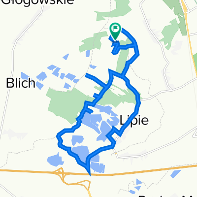 Tour de Lipie
- Distance
- 13.7 km
- Ascent
- 58 m
- Descent
- 55 m
- Location
- Głogów Małopolski, Subcarpathian Voivodeship, Poland
Open it in the app