

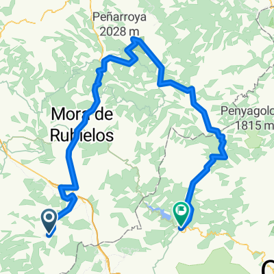
Manzanera-Utiel
A cycling route starting in Manzanera, Aragon, Spain.
Overview
About this route
Manzanera - Abejuela - La Yesa - Alpuente - Titaguas - Tuejar - Benagéber - Utiel
- -:--
- Duration
- 108.5 km
- Distance
- 1,454 m
- Ascent
- 1,697 m
- Descent
- ---
- Avg. speed
- ---
- Max. altitude
Route quality
Waytypes & surfaces along the route
Waytypes
Quiet road
25 km
(23 %)
Road
20.6 km
(19 %)
Surfaces
Paved
4.3 km
(4 %)
Paved (undefined)
4.3 km
(4 %)
Undefined
104.2 km
(96 %)
Continue with Bikemap
Use, edit, or download this cycling route
You would like to ride Manzanera-Utiel or customize it for your own trip? Here is what you can do with this Bikemap route:
Free features
- Save this route as favorite or in collections
- Copy & plan your own version of this route
- Split it into stages to create a multi-day tour
- Sync your route with Garmin or Wahoo
Premium features
Free trial for 3 days, or one-time payment. More about Bikemap Premium.
- Navigate this route on iOS & Android
- Export a GPX / KML file of this route
- Create your custom printout (try it for free)
- Download this route for offline navigation
Discover more Premium features.
Get Bikemap PremiumFrom our community
Other popular routes starting in Manzanera
 Picon del Buitre desde Manzanera
- Distance
- 97.4 km
- Ascent
- 1,988 m
- Descent
- 1,991 m
- Location
- Manzanera, Aragon, Spain
 PICON DEL BUITRE EI TEAM. CIRCULAR
- Distance
- 113.8 km
- Ascent
- 2,108 m
- Descent
- 2,106 m
- Location
- Manzanera, Aragon, Spain
 CEREZOS LA YESA
- Distance
- 60.5 km
- Ascent
- 868 m
- Descent
- 868 m
- Location
- Manzanera, Aragon, Spain
 mitic trail etapa 3
- Distance
- 128.2 km
- Ascent
- 0 m
- Descent
- 0 m
- Location
- Manzanera, Aragon, Spain
 Picon del Buitre EI-team
- Distance
- 99.3 km
- Ascent
- 1,925 m
- Descent
- 1,925 m
- Location
- Manzanera, Aragon, Spain
 Los Cerezos-Ermita Sta.Margarita-Torrijos
- Distance
- 42.9 km
- Ascent
- 608 m
- Descent
- 607 m
- Location
- Manzanera, Aragon, Spain
 2ª Manzanera_Montanejos
- Distance
- 131.8 km
- Ascent
- 1,957 m
- Descent
- 2,478 m
- Location
- Manzanera, Aragon, Spain
 Manzanera-Valdelinares
- Distance
- 118.8 km
- Ascent
- 1,709 m
- Descent
- 1,709 m
- Location
- Manzanera, Aragon, Spain
Open it in the app