

Redwood Heights / Montclair / Tunnel Rd / Skyline /Redwood Heights
A cycling route starting in Piedmont, California, United States.
Overview
About this route
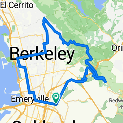
A great little 1 hour workout. The loop has a great mixture of terrains, roads and views... from suburban busy streets, to Redwood trees, to hilltop grand views of the east bay with San Francisco across the bay. Tunnel Road is a great mid route section to test yourself.
- -:--
- Duration
- 25.2 km
- Distance
- 966 m
- Ascent
- 926 m
- Descent
- ---
- Avg. speed
- 453 m
- Max. altitude

Route quality
Waytypes & surfaces along the route
Waytypes
Road
11.8 km
(47 %)
Cycleway
0.8 km
(3 %)
Surfaces
Paved
14.1 km
(56 %)
Asphalt
13.4 km
(53 %)
Concrete
0.8 km
(3 %)
Undefined
11.1 km
(44 %)
Continue with Bikemap
Use, edit, or download this cycling route
You would like to ride Redwood Heights / Montclair / Tunnel Rd / Skyline /Redwood Heights or customize it for your own trip? Here is what you can do with this Bikemap route:
Free features
- Save this route as favorite or in collections
- Copy & plan your own version of this route
- Sync your route with Garmin or Wahoo
Premium features
Free trial for 3 days, or one-time payment. More about Bikemap Premium.
- Navigate this route on iOS & Android
- Export a GPX / KML file of this route
- Create your custom printout (try it for free)
- Download this route for offline navigation
Discover more Premium features.
Get Bikemap PremiumFrom our community
Other popular routes starting in Piedmont
 Tunnel Road | Oakland, CA, USA
- Distance
- 4.6 km
- Ascent
- 406 m
- Descent
- 187 m
- Location
- Piedmont, California, United States
 Redwood Regional park 25
- Distance
- 25.5 km
- Ascent
- 594 m
- Descent
- 622 m
- Location
- Piedmont, California, United States
 Around downtown Oakland
- Distance
- 16.6 km
- Ascent
- 67 m
- Descent
- 67 m
- Location
- Piedmont, California, United States
 Park - Snake - Skyline - Redwood - Pinehurst Loop
- Distance
- 38.2 km
- Ascent
- 720 m
- Descent
- 720 m
- Location
- Piedmont, California, United States
 Over-the-Hills Loop
- Distance
- 44.3 km
- Ascent
- 723 m
- Descent
- 546 m
- Location
- Piedmont, California, United States
 Redwood Heights / Montclair / Tunnel Rd / Skyline /Redwood Heights
- Distance
- 25.2 km
- Ascent
- 966 m
- Descent
- 926 m
- Location
- Piedmont, California, United States
 grizzly to viks
- Distance
- 37.3 km
- Ascent
- 628 m
- Descent
- 626 m
- Location
- Piedmont, California, United States
 Hill Bomb Redwood to Lake Merritt
- Distance
- 17.8 km
- Ascent
- 152 m
- Descent
- 541 m
- Location
- Piedmont, California, United States
Open it in the app