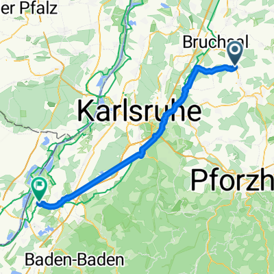
Gondelsheim KIT CN V1
A cycling route starting in Gondelsheim, Baden-Wurttemberg, Germany.
Overview
About this route
Wenig Höhenmeter, dafür etwas Straße
- -:--
- Duration
- 21.2 km
- Distance
- 104 m
- Ascent
- 147 m
- Descent
- ---
- Avg. speed
- ---
- Max. altitude
Route quality
Waytypes & surfaces along the route
Waytypes
Track
8.3 km
(39 %)
Path
5.1 km
(24 %)
Surfaces
Paved
16.3 km
(77 %)
Unpaved
4 km
(19 %)
Asphalt
15 km
(71 %)
Concrete
1.3 km
(6 %)
Continue with Bikemap
Use, edit, or download this cycling route
You would like to ride Gondelsheim KIT CN V1 or customize it for your own trip? Here is what you can do with this Bikemap route:
Free features
- Save this route as favorite or in collections
- Copy & plan your own version of this route
- Sync your route with Garmin or Wahoo
Premium features
Free trial for 3 days, or one-time payment. More about Bikemap Premium.
- Navigate this route on iOS & Android
- Export a GPX / KML file of this route
- Create your custom printout (try it for free)
- Download this route for offline navigation
Discover more Premium features.
Get Bikemap PremiumFrom our community
Other popular routes starting in Gondelsheim
- Dossental, Gondelsheim nach Im Tal 15, Bretten
- Distance
- 5.6 km
- Ascent
- 90 m
- Descent
- 135 m
- Location
- Gondelsheim, Baden-Wurttemberg, Germany
- Weingarten-Katzenbuckel-Untergrombach-Michaelsberg-Obergrombach-Gondelsheim
- Distance
- 35.5 km
- Ascent
- 654 m
- Descent
- 654 m
- Location
- Gondelsheim, Baden-Wurttemberg, Germany
- Vatertagsroute
- Distance
- 34.3 km
- Ascent
- 294 m
- Descent
- 298 m
- Location
- Gondelsheim, Baden-Wurttemberg, Germany
- Rauf und Runtertour im Kraichgau
- Distance
- 45.8 km
- Ascent
- 470 m
- Descent
- 472 m
- Location
- Gondelsheim, Baden-Wurttemberg, Germany
- Gondelsheim Büchenbronn
- Distance
- 27.1 km
- Ascent
- 651 m
- Descent
- 428 m
- Location
- Gondelsheim, Baden-Wurttemberg, Germany
- Kraichgaurunde Nr.1
- Distance
- 56.7 km
- Ascent
- 568 m
- Descent
- 568 m
- Location
- Gondelsheim, Baden-Wurttemberg, Germany
- An den Stromnberg
- Distance
- 58.4 km
- Ascent
- 966 m
- Descent
- 941 m
- Location
- Gondelsheim, Baden-Wurttemberg, Germany
- MIchaelsberg Runde 3
- Distance
- 43.5 km
- Ascent
- 611 m
- Descent
- 611 m
- Location
- Gondelsheim, Baden-Wurttemberg, Germany
Open it in the app