

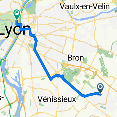
St Priest-Mions-Valencin-LePeage-Serpaize-VilletteDeVienne-Marennes-Chaponnay-Mions- St Priest
A cycling route starting in Saint-Priest, Auvergne-Rhône-Alpes, France.
Overview
About this route
St Priest-Mions-Valencin-LePeage-Serpaize-VilletteDeVienne-Marennes-Chaponnay-Mions- St Priest
- -:--
- Duration
- 51.7 km
- Distance
- 446 m
- Ascent
- 444 m
- Descent
- ---
- Avg. speed
- ---
- Max. altitude
Route quality
Waytypes & surfaces along the route
Waytypes
Road
18.9 km
(37 %)
Quiet road
15 km
(29 %)
Surfaces
Paved
18.6 km
(36 %)
Asphalt
18.6 km
(36 %)
Paved (undefined)
0 km
(<1 %)
Undefined
33.1 km
(64 %)
Continue with Bikemap
Use, edit, or download this cycling route
You would like to ride St Priest-Mions-Valencin-LePeage-Serpaize-VilletteDeVienne-Marennes-Chaponnay-Mions- St Priest or customize it for your own trip? Here is what you can do with this Bikemap route:
Free features
- Save this route as favorite or in collections
- Copy & plan your own version of this route
- Sync your route with Garmin or Wahoo
Premium features
Free trial for 3 days, or one-time payment. More about Bikemap Premium.
- Navigate this route on iOS & Android
- Export a GPX / KML file of this route
- Create your custom printout (try it for free)
- Download this route for offline navigation
Discover more Premium features.
Get Bikemap PremiumFrom our community
Other popular routes starting in Saint-Priest
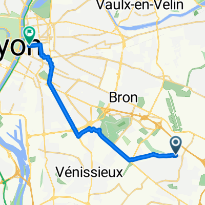 From Saint-Priest to Lyon
- Distance
- 13.4 km
- Ascent
- 43 m
- Descent
- 84 m
- Location
- Saint-Priest, Auvergne-Rhône-Alpes, France
 Montventoux
- Distance
- 242.2 km
- Ascent
- 2,767 m
- Descent
- 1,222 m
- Location
- Saint-Priest, Auvergne-Rhône-Alpes, France
 St Priest-Mions-Valencin-LePeage-Serpaize-VilletteDeVienne-Marennes-Chaponnay-Mions- St Priest
- Distance
- 51.7 km
- Ascent
- 446 m
- Descent
- 444 m
- Location
- Saint-Priest, Auvergne-Rhône-Alpes, France
 Rue Marcel Proust ~ Place des Terreaux
- Distance
- 14.7 km
- Ascent
- 55 m
- Descent
- 82 m
- Location
- Saint-Priest, Auvergne-Rhône-Alpes, France
 Vilette
- Distance
- 67.2 km
- Ascent
- 451 m
- Descent
- 451 m
- Location
- Saint-Priest, Auvergne-Rhône-Alpes, France
 Boulot Maison 2
- Distance
- 11 km
- Ascent
- 65 m
- Descent
- 70 m
- Location
- Saint-Priest, Auvergne-Rhône-Alpes, France
 2 Rue Johanny-Berlioz, Saint-Priest à 22 Rue de l'Espérance, Vaulx-en-Velin
- Distance
- 11.2 km
- Ascent
- 83 m
- Descent
- 110 m
- Location
- Saint-Priest, Auvergne-Rhône-Alpes, France
 test
test- Distance
- 2.7 km
- Ascent
- 19 m
- Descent
- 28 m
- Location
- Saint-Priest, Auvergne-Rhône-Alpes, France
Open it in the app