

entrainement >110
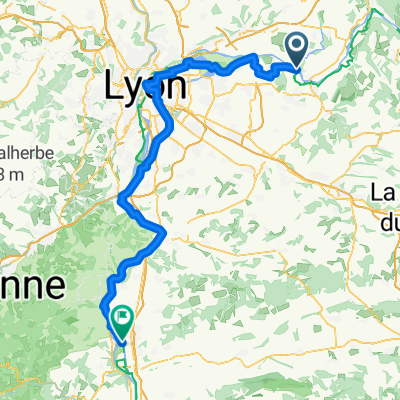
A cycling route starting in Chavanoz, Auvergne-Rhône-Alpes, France.
Overview
About this route
entrainement montée vosges
- -:--
- Duration
- 115.8 km
- Distance
- 724 m
- Ascent
- 724 m
- Descent
- ---
- Avg. speed
- ---
- Max. altitude
Route quality
Waytypes & surfaces along the route
Waytypes
Road
55.6 km
(48 %)
Quiet road
35.9 km
(31 %)
Surfaces
Paved
37 km
(32 %)
Unpaved
1.2 km
(1 %)
Asphalt
37 km
(32 %)
Ground
1.2 km
(1 %)
Undefined
77.6 km
(67 %)
Continue with Bikemap
Use, edit, or download this cycling route
You would like to ride entrainement >110 or customize it for your own trip? Here is what you can do with this Bikemap route:
Free features
- Save this route as favorite or in collections
- Copy & plan your own version of this route
- Split it into stages to create a multi-day tour
- Sync your route with Garmin or Wahoo
Premium features
Free trial for 3 days, or one-time payment. More about Bikemap Premium.
- Navigate this route on iOS & Android
- Export a GPX / KML file of this route
- Create your custom printout (try it for free)
- Download this route for offline navigation
Discover more Premium features.
Get Bikemap PremiumFrom our community
Other popular routes starting in Chavanoz
 De Résidence Chantemerle 3, Chavanoz à Route de Luzinay 800, Saint-Just-Chaleyssin
- Distance
- 29.8 km
- Ascent
- 173 m
- Descent
- 143 m
- Location
- Chavanoz, Auvergne-Rhône-Alpes, France
 entrainement Saint chef
- Distance
- 88.8 km
- Ascent
- 685 m
- Descent
- 684 m
- Location
- Chavanoz, Auvergne-Rhône-Alpes, France
 Etape 10 - Anthon - Frangy
- Distance
- 125 km
- Ascent
- 439 m
- Descent
- 319 m
- Location
- Chavanoz, Auvergne-Rhône-Alpes, France
 De Chemin de Mons À Anthon à Route de Vienne 66, Charvieu-Chavagneux
- Distance
- 21 km
- Ascent
- 106 m
- Descent
- 131 m
- Location
- Chavanoz, Auvergne-Rhône-Alpes, France
 entrainement >110
- Distance
- 115.8 km
- Ascent
- 724 m
- Descent
- 724 m
- Location
- Chavanoz, Auvergne-Rhône-Alpes, France
 Chavanoz - Le Péage-de-Roussillon
- Distance
- 106.6 km
- Ascent
- 644 m
- Descent
- 720 m
- Location
- Chavanoz, Auvergne-Rhône-Alpes, France
 6 Lotissement Les Vermillières, Chavanoz à 21 Rue Gambetta, Fontaines-sur-Saône
- Distance
- 39.5 km
- Ascent
- 348 m
- Descent
- 386 m
- Location
- Chavanoz, Auvergne-Rhône-Alpes, France
 Parcours sportif
- Distance
- 29.8 km
- Ascent
- 109 m
- Descent
- 113 m
- Location
- Chavanoz, Auvergne-Rhône-Alpes, France
Open it in the app