

Rondje Moerenburg LaTrappe
A cycling route starting in Goirle, North Brabant, The Netherlands.
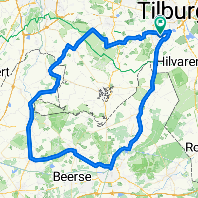
Overview
About this route
Hilvarenbeek
Biest-Houtakker Moergestel Heukelom Moerenburg Koningshoeven - La Trappe Tilburg Goirle- -:--
- Duration
- 31.5 km
- Distance
- 28 m
- Ascent
- 30 m
- Descent
- ---
- Avg. speed
- ---
- Max. altitude
Route quality
Waytypes & surfaces along the route
Waytypes
Quiet road
14.2 km
(45 %)
Cycleway
13.2 km
(42 %)
Road
4.1 km
(13 %)
Surfaces
Paved
14.5 km
(46 %)
Asphalt
14.5 km
(46 %)
Undefined
17 km
(54 %)
Continue with Bikemap
Use, edit, or download this cycling route
You would like to ride Rondje Moerenburg LaTrappe or customize it for your own trip? Here is what you can do with this Bikemap route:
Free features
- Save this route as favorite or in collections
- Copy & plan your own version of this route
- Sync your route with Garmin or Wahoo
Premium features
Free trial for 3 days, or one-time payment. More about Bikemap Premium.
- Navigate this route on iOS & Android
- Export a GPX / KML file of this route
- Create your custom printout (try it for free)
- Download this route for offline navigation
Discover more Premium features.
Get Bikemap PremiumFrom our community
Other popular routes starting in Goirle
 ZO 80 - Goirle - Hilvarenbeek - Baarschot - Vessem - Knegsel - Duizel - Hoogeloon - Casteren - Hulsel - Hooge Mierde - Poppel - Goirle
- Distance
- 79.8 km
- Ascent
- 58 m
- Descent
- 60 m
- Location
- Goirle, North Brabant, The Netherlands
 Tlb,Glz,Alph,B-N,Pppl,Sbk,Hbk,Grl.
- Distance
- 55.4 km
- Ascent
- 70 m
- Descent
- 69 m
- Location
- Goirle, North Brabant, The Netherlands
 Ronde Goirle Reusel Poppel
- Distance
- 53.6 km
- Ascent
- 57 m
- Descent
- 59 m
- Location
- Goirle, North Brabant, The Netherlands
 3-Uurs trainingsronde
- Distance
- 87 km
- Ascent
- 43 m
- Descent
- 44 m
- Location
- Goirle, North Brabant, The Netherlands
 N 75 - Goirle - kanaal - Berkel Enschot - Drunense Duinen - Giersbergen - Cromvoirt - Haaren - Oisterwijk - Moergestel - Goirle
- Distance
- 75.1 km
- Ascent
- 39 m
- Descent
- 42 m
- Location
- Goirle, North Brabant, The Netherlands
 Pondjes route
- Distance
- 64.5 km
- Ascent
- 53 m
- Descent
- 56 m
- Location
- Goirle, North Brabant, The Netherlands
 MTB de Hellen
- Distance
- 61.2 km
- Ascent
- 80 m
- Descent
- 80 m
- Location
- Goirle, North Brabant, The Netherlands
 ZW 110 - Goirle - Hilvarenbeek - Diessen - Baarschot - Vessem - Duizel - kanaal bij Arendonk - Turnhout - Merksplas - Zondereigen - Baarle Nassau - Bels Lijntje
- Distance
- 110 km
- Ascent
- 76 m
- Descent
- 78 m
- Location
- Goirle, North Brabant, The Netherlands
Open it in the app