

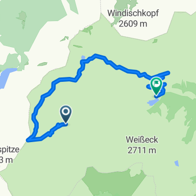
Glettnalm
A cycling route starting in Hüttschlag, Salzburg, Austria.
Overview
About this route
Unfortunately, there are no trials on this route.
- -:--
- Duration
- 46.5 km
- Distance
- 974 m
- Ascent
- 972 m
- Descent
- ---
- Avg. speed
- ---
- Max. altitude
Continue with Bikemap
Use, edit, or download this cycling route
You would like to ride Glettnalm or customize it for your own trip? Here is what you can do with this Bikemap route:
Free features
- Save this route as favorite or in collections
- Copy & plan your own version of this route
- Sync your route with Garmin or Wahoo
Premium features
Free trial for 3 days, or one-time payment. More about Bikemap Premium.
- Navigate this route on iOS & Android
- Export a GPX / KML file of this route
- Create your custom printout (try it for free)
- Download this route for offline navigation
Discover more Premium features.
Get Bikemap PremiumFrom our community
Other popular routes starting in Hüttschlag
 Mur-Rad - 2
- Distance
- 46 km
- Ascent
- 29 m
- Descent
- 911 m
- Location
- Hüttschlag, Salzburg, Austria
 Glettnalm
- Distance
- 46.5 km
- Ascent
- 974 m
- Descent
- 972 m
- Location
- Hüttschlag, Salzburg, Austria
 Murradweg; vom Murursprung bis Leibnitz
- Distance
- 309.5 km
- Ascent
- 84 m
- Descent
- 1,712 m
- Location
- Hüttschlag, Salzburg, Austria
 Großarl - Speicher - Bad Gastein
- Distance
- 28.2 km
- Ascent
- 1,983 m
- Descent
- 2,000 m
- Location
- Hüttschlag, Salzburg, Austria
 Wald 28, Zederhaus nach Poststraße 408, Sankt Michael im Lungau
- Distance
- 29.6 km
- Ascent
- 70 m
- Descent
- 729 m
- Location
- Hüttschlag, Salzburg, Austria
 Lungau 02 Riedental Höhenweg
- Distance
- 13.7 km
- Ascent
- 731 m
- Descent
- 912 m
- Location
- Hüttschlag, Salzburg, Austria
 Großarl
- Distance
- 17.9 km
- Ascent
- 67 m
- Descent
- 300 m
- Location
- Hüttschlag, Salzburg, Austria
 Austrai06
- Distance
- 48 km
- Ascent
- 175 m
- Descent
- 656 m
- Location
- Hüttschlag, Salzburg, Austria
Open it in the app