

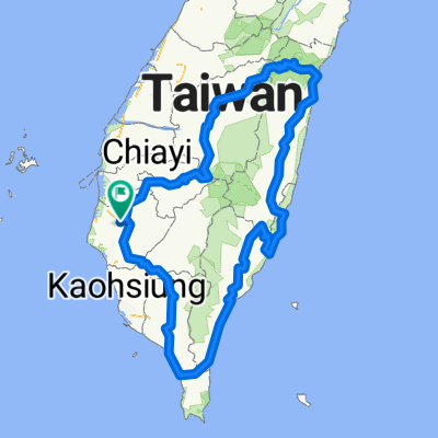
鹽水 奮起湖
A cycling route starting in Xinying District, Taiwan, Taiwan.
Overview
About this route
There are really a lot of cars, and under these conditions, it's better not to come here by bike. The officers at the Xiding police station told me that there are too many cars and the roads are too narrow, plus not every tour bus driver is very skilled.
- 9 h 34 min
- Duration
- 164.5 km
- Distance
- 1,400 m
- Ascent
- 1,402 m
- Descent
- 17.2 km/h
- Avg. speed
- ---
- Max. altitude

Route quality
Waytypes & surfaces along the route
Waytypes
Quiet road
14.8 km
(9 %)
Road
9.9 km
(6 %)
Surfaces
Paved
121.7 km
(74 %)
Asphalt
121.7 km
(74 %)
Undefined
42.8 km
(26 %)
Continue with Bikemap
Use, edit, or download this cycling route
You would like to ride 鹽水 奮起湖 or customize it for your own trip? Here is what you can do with this Bikemap route:
Free features
- Save this route as favorite or in collections
- Copy & plan your own version of this route
- Split it into stages to create a multi-day tour
- Sync your route with Garmin or Wahoo
Premium features
Free trial for 3 days, or one-time payment. More about Bikemap Premium.
- Navigate this route on iOS & Android
- Export a GPX / KML file of this route
- Create your custom printout (try it for free)
- Download this route for offline navigation
Discover more Premium features.
Get Bikemap PremiumFrom our community
Other popular routes starting in Xinying District
 1XXKM
1XXKM- Distance
- 117.8 km
- Ascent
- 1,034 m
- Descent
- 1,043 m
- Location
- Xinying District, Taiwan, Taiwan
 冬山咖啡節4+2
- Distance
- 19 km
- Ascent
- 347 m
- Descent
- 162 m
- Location
- Xinying District, Taiwan, Taiwan
 鹽水 奮起湖
- Distance
- 164.5 km
- Ascent
- 1,400 m
- Descent
- 1,402 m
- Location
- Xinying District, Taiwan, Taiwan
 2012 Never Stop 鯤鯓王有保庇極限挑戰200K
- Distance
- 222.9 km
- Ascent
- 33 m
- Descent
- 35 m
- Location
- Xinying District, Taiwan, Taiwan
 Tour 台南後壁 - 高雄 (實騎版)
- Distance
- 132.4 km
- Ascent
- 772 m
- Descent
- 789 m
- Location
- Xinying District, Taiwan, Taiwan
 175東山咖啡公路
- Distance
- 76.4 km
- Ascent
- 901 m
- Descent
- 901 m
- Location
- Xinying District, Taiwan, Taiwan
 Kaohsiung
- Distance
- 85.7 km
- Ascent
- 83 m
- Descent
- 79 m
- Location
- Xinying District, Taiwan, Taiwan
 純屬測試
純屬測試- Distance
- 872.4 km
- Ascent
- 6,685 m
- Descent
- 6,686 m
- Location
- Xinying District, Taiwan, Taiwan
Open it in the app