

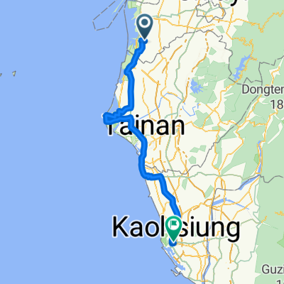
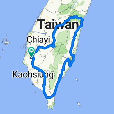
鹽水 奮起湖
A cycling route starting in Xinying District, Taiwan, Taiwan.
Overview
About this route
大車小車真的很多,現在這個狀況應該不適合騎自行車上來。
隙頂派出所員警這樣告訴我的車太多路太小,加上遊覽車司機技術不是每個都很好。- 9 h 34 min
- Duration
- 164.5 km
- Distance
- 1,400 m
- Ascent
- 1,402 m
- Descent
- 17.2 km/h
- Avg. speed
- ---
- Avg. speed

Route quality
Waytypes & surfaces along the route
Waytypes
Busy road
134.2 km
(82 %)
Quiet road
10.3 km
(6 %)
Surfaces
Paved
123.5 km
(75 %)
Asphalt
123.3 km
(75 %)
Paved (undefined)
0.2 km
(<1 %)
Undefined
41 km
(25 %)
Continue with Bikemap
Use, edit, or download this cycling route
You would like to ride 鹽水 奮起湖 or customize it for your own trip? Here is what you can do with this Bikemap route:
Free features
- Save this route as favorite or in collections
- Copy & plan your own version of this route
- Sync your route with Garmin or Wahoo
Premium features
Free trial for 3 days, or one-time payment. More about Bikemap Premium.
- Navigate this route on iOS & Android
- Export a GPX / KML file of this route
- Create your custom printout (try it for free)
- Download this route for offline navigation
Discover more Premium features.
Get Bikemap PremiumFrom our community
Other popular routes starting in Xinying District
 冬山咖啡節4+2
- Distance
- 19 km
- Ascent
- 347 m
- Descent
- 162 m
- Location
- Xinying District, Taiwan, Taiwan
 Tour 南嘉雲彰(實騎版) 110409
- Distance
- 93.1 km
- Ascent
- 44 m
- Descent
- 54 m
- Location
- Xinying District, Taiwan, Taiwan
 Day 4
Day 4- Distance
- 126 km
- Ascent
- 68 m
- Descent
- 58 m
- Location
- Xinying District, Taiwan, Taiwan
 鹽水 奮起湖
- Distance
- 164.5 km
- Ascent
- 1,400 m
- Descent
- 1,402 m
- Location
- Xinying District, Taiwan, Taiwan
 175東山咖啡公路
- Distance
- 76.4 km
- Ascent
- 901 m
- Descent
- 901 m
- Location
- Xinying District, Taiwan, Taiwan
 1XXKM
1XXKM- Distance
- 117.8 km
- Ascent
- 1,034 m
- Descent
- 1,043 m
- Location
- Xinying District, Taiwan, Taiwan
 2012 Never Stop 鯤鯓王有保庇極限挑戰200K
- Distance
- 222.9 km
- Ascent
- 33 m
- Descent
- 35 m
- Location
- Xinying District, Taiwan, Taiwan
 純屬測試
純屬測試- Distance
- 872.4 km
- Ascent
- 6,685 m
- Descent
- 6,686 m
- Location
- Xinying District, Taiwan, Taiwan
Open it in the app