Oberbipp bis Chasseral
A cycling route starting in Oberbipp, Canton of Bern, Switzerland.
Overview
About this route
44MTB geplant, noch nicht selber gefahren!
(cloned from route 3217031) (cloned from route 3217035)- -:--
- Duration
- 75.8 km
- Distance
- 2,546 m
- Ascent
- 1,509 m
- Descent
- ---
- Avg. speed
- ---
- Avg. speed
Route quality
Waytypes & surfaces along the route
Waytypes
Track
38 km
(50 %)
Quiet road
19 km
(25 %)
Surfaces
Paved
21.5 km
(28 %)
Unpaved
41.6 km
(55 %)
Gravel
23.1 km
(30 %)
Asphalt
17.2 km
(23 %)
Continue with Bikemap
Use, edit, or download this cycling route
You would like to ride Oberbipp bis Chasseral or customize it for your own trip? Here is what you can do with this Bikemap route:
Free features
- Save this route as favorite or in collections
- Copy & plan your own version of this route
- Sync your route with Garmin or Wahoo
Premium features
Free trial for 3 days, or one-time payment. More about Bikemap Premium.
- Navigate this route on iOS & Android
- Export a GPX / KML file of this route
- Create your custom printout (try it for free)
- Download this route for offline navigation
Discover more Premium features.
Get Bikemap PremiumFrom our community
Other popular routes starting in Oberbipp
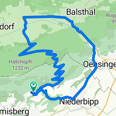
- Wolfisberg-Balsthal-Niederbipp-Wolfisberg
- Distance
- 24.5 km
- Ascent
- 684 m
- Descent
- 684 m
- Location
- Oberbipp, Canton of Bern, Switzerland
- Oberbipp bis Chasseral
- Distance
- 75.8 km
- Ascent
- 2,546 m
- Descent
- 1,509 m
- Location
- Oberbipp, Canton of Bern, Switzerland
- Buchliweg, Oberbipp nach Buchlistrasse 37, Niederbipp
- Distance
- 8.7 km
- Ascent
- 178 m
- Descent
- 168 m
- Location
- Oberbipp, Canton of Bern, Switzerland
- AAreroute
- Distance
- 21.9 km
- Ascent
- 176 m
- Descent
- 178 m
- Location
- Oberbipp, Canton of Bern, Switzerland
- Kirchgasse 1B, Oberbipp nach Wasen im Emmental
- Distance
- 40.4 km
- Ascent
- 715 m
- Descent
- 397 m
- Location
- Oberbipp, Canton of Bern, Switzerland
- Sägetweg 18, Oberbipp nach Hauptstrasse 47–49, Solothurn
- Distance
- 20.4 km
- Ascent
- 144 m
- Descent
- 196 m
- Location
- Oberbipp, Canton of Bern, Switzerland
- Steingasse 28, Oberbipp nach Hauptgasse 66, Solothurn
- Distance
- 12.1 km
- Ascent
- 72 m
- Descent
- 113 m
- Location
- Oberbipp, Canton of Bern, Switzerland
- Aarerunde
- Distance
- 30.3 km
- Ascent
- 206 m
- Descent
- 203 m
- Location
- Oberbipp, Canton of Bern, Switzerland
Open it in the app