95 % Schotter Tour/2
A cycling route starting in Dietenhofen, Bavaria, Germany.
Overview
About this route
Mainly on forest and meadow trails to the new wind farms
Average of 19.2, 1047 D+, 190 Wh, 150 Hf, 54 Tf Average of 16,_________ 125 Wh, 144 Hf, 62 Tf- -:--
- Duration
- 43.8 km
- Distance
- 439 m
- Ascent
- 439 m
- Descent
- ---
- Avg. speed
- ---
- Max. altitude
Route quality
Waytypes & surfaces along the route
Waytypes
Track
39 km
(89 %)
Quiet road
4.4 km
(10 %)
Undefined
0.4 km
(1 %)
Surfaces
Paved
3.9 km
(9 %)
Unpaved
29.3 km
(67 %)
Gravel
22.8 km
(52 %)
Ground
3.9 km
(9 %)
Route highlights
Points of interest along the route
Point of interest after 31.1 km
wea 3
Point of interest after 31.7 km
wea 4
Point of interest after 31.9 km
wea 2
Point of interest after 32.7 km
wea 1
Continue with Bikemap
Use, edit, or download this cycling route
You would like to ride 95 % Schotter Tour/2 or customize it for your own trip? Here is what you can do with this Bikemap route:
Free features
- Save this route as favorite or in collections
- Copy & plan your own version of this route
- Sync your route with Garmin or Wahoo
Premium features
Free trial for 3 days, or one-time payment. More about Bikemap Premium.
- Navigate this route on iOS & Android
- Export a GPX / KML file of this route
- Create your custom printout (try it for free)
- Download this route for offline navigation
Discover more Premium features.
Get Bikemap PremiumFrom our community
Other popular routes starting in Dietenhofen
Rundtour "Bibert-Tal"- Distance
- 29.2 km
- Ascent
- 207 m
- Descent
- 207 m
- Location
- Dietenhofen, Bavaria, Germany
Rundtour "Mettlachtal"- Distance
- 25.2 km
- Ascent
- 271 m
- Descent
- 271 m
- Location
- Dietenhofen, Bavaria, Germany
Rundtour "Cadolzburg"- Distance
- 41.7 km
- Ascent
- 257 m
- Descent
- 257 m
- Location
- Dietenhofen, Bavaria, Germany
Rundtour "Trautskirchen/Merzbach/Neuhof"- Distance
- 35.2 km
- Ascent
- 362 m
- Descent
- 362 m
- Location
- Dietenhofen, Bavaria, Germany
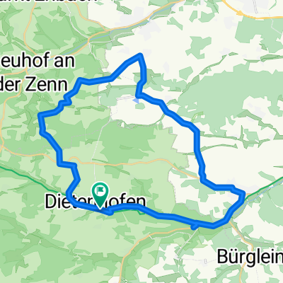
MTB Rundtour "Sieben Richter"- Distance
- 17.7 km
- Ascent
- 245 m
- Descent
- 245 m
- Location
- Dietenhofen, Bavaria, Germany
3-Tagestour 2013 "Kneippradweg"- Distance
- 175.8 km
- Ascent
- 655 m
- Descent
- 655 m
- Location
- Dietenhofen, Bavaria, Germany
Rundtour "Sonnensee"- Distance
- 46.5 km
- Ascent
- 282 m
- Descent
- 285 m
- Location
- Dietenhofen, Bavaria, Germany
95 % Schotter Tour/2- Distance
- 43.8 km
- Ascent
- 439 m
- Descent
- 439 m
- Location
- Dietenhofen, Bavaria, Germany
Open it in the app


