

Col d'Evosges and Jura Col Hunting
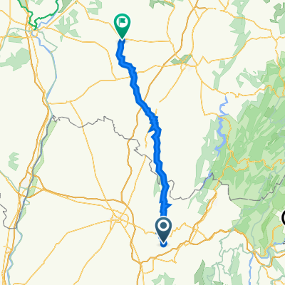
A cycling route starting in Poncin, Auvergne-Rhône-Alpes, France.
Overview
About this route
A fun loop tracking down 5 Cols. Col d'Evosges is beautiful
95% paved. Took a couple of unplanned shortcuts over farm fields due to bad GPS planning. COuld easily avoid these though. (cloned from route 2537978)- -:--
- Duration
- 63.4 km
- Distance
- 1,384 m
- Ascent
- 1,213 m
- Descent
- ---
- Avg. speed
- ---
- Max. altitude
Route quality
Waytypes & surfaces along the route
Waytypes
Road
45 km
(71 %)
Track
1.3 km
(2 %)
Surfaces
Paved
7 km
(11 %)
Asphalt
7 km
(11 %)
Undefined
56.4 km
(89 %)
Route highlights
Points of interest along the route
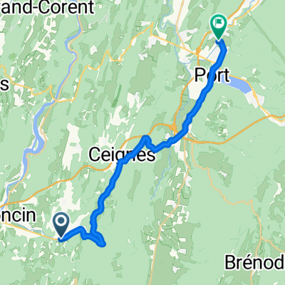
Point of interest after 8.2 km
Col de Montratier - 500 metres
Point of interest after 18.1 km
Col du Cendrier - 793 metres
Point of interest after 26.3 km
Col du Nivolet - 602 metres
Point of interest after 41.3 km
Col d'Evosges - 758 metres
Point of interest after 60.6 km
Col du Sappel - 794 metres
Continue with Bikemap
Use, edit, or download this cycling route
You would like to ride Col d'Evosges and Jura Col Hunting or customize it for your own trip? Here is what you can do with this Bikemap route:
Free features
- Save this route as favorite or in collections
- Copy & plan your own version of this route
- Sync your route with Garmin or Wahoo
Premium features
Free trial for 3 days, or one-time payment. More about Bikemap Premium.
- Navigate this route on iOS & Android
- Export a GPX / KML file of this route
- Create your custom printout (try it for free)
- Download this route for offline navigation
Discover more Premium features.
Get Bikemap PremiumFrom our community
Other popular routes starting in Poncin
 Poncin - Bourcia
- Distance
- 43.5 km
- Ascent
- 681 m
- Descent
- 571 m
- Location
- Poncin, Auvergne-Rhône-Alpes, France
 Fietsvakantie 19-07 Allement - Saint-Germain-du-Bois
- Distance
- 86 km
- Ascent
- 883 m
- Descent
- 963 m
- Location
- Poncin, Auvergne-Rhône-Alpes, France
 Col d'Evosges and Jura Col Hunting
- Distance
- 63.4 km
- Ascent
- 1,384 m
- Descent
- 1,213 m
- Location
- Poncin, Auvergne-Rhône-Alpes, France
 Bourg-en-Bresse: vallée de l'Ain
- Distance
- 58.7 km
- Ascent
- 783 m
- Descent
- 785 m
- Location
- Poncin, Auvergne-Rhône-Alpes, France
 Gorges de l'Ain and Col du Berthiand
- Distance
- 74 km
- Ascent
- 1,052 m
- Descent
- 1,052 m
- Location
- Poncin, Auvergne-Rhône-Alpes, France
 poncin - montrevel 65 km
- Distance
- 64.8 km
- Ascent
- 299 m
- Descent
- 364 m
- Location
- Poncin, Auvergne-Rhône-Alpes, France
 Stage 7 50 Years CSi
- Distance
- 153.1 km
- Ascent
- 613 m
- Descent
- 649 m
- Location
- Poncin, Auvergne-Rhône-Alpes, France
 retour partie 2
- Distance
- 21.9 km
- Ascent
- 447 m
- Descent
- 300 m
- Location
- Poncin, Auvergne-Rhône-Alpes, France
Open it in the app