
Hôtel de la Buffe, tour des plateaux Nord.
A cycling route starting in Autrans, Auvergne-Rhône-Alpes, France.
Overview
About this route
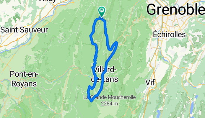
After the delicious breakfast at the hotel de la Buffe, you will head towards Méaudre via the old road. You will descend the fresh gorges of the Méaudret to the Jarrands. The first challenge of the day presents itself: the col du Liorin via the Olivets. At the pass, in front of you, the majestic peaks of the grandes and petites Moucherolles overlook the ski slopes of the Villard Corrençon ski area. We invite you to reach the Golf of Corrençon by crossing the forest of Loubière, a small playful part of the whole area via the cross-country ski trails. The stop at the restaurant Le 19 is a must. The welcome is as warm as its terrace. Its menu, composed of excellent quality products, is a condensed array of subtle flavors. Refreshed, you will descend to Villard de Lans along the Corrençonnais. A ride in the plains of Lans, along the old tramway, will lead you to the foot of the last pass of the day, keeping you safe from the cars. You will find your cozy nest at the hotel de la Buffe, where Régis, an authentic chef, will share his performances with you.
- -:--
- Duration
- 46.8 km
- Distance
- 678 m
- Ascent
- 679 m
- Descent
- ---
- Avg. speed
- ---
- Max. altitude
Continue with Bikemap
Use, edit, or download this cycling route
You would like to ride Hôtel de la Buffe, tour des plateaux Nord. or customize it for your own trip? Here is what you can do with this Bikemap route:
Free features
- Save this route as favorite or in collections
- Copy & plan your own version of this route
- Sync your route with Garmin or Wahoo
Premium features
Free trial for 3 days, or one-time payment. More about Bikemap Premium.
- Navigate this route on iOS & Android
- Export a GPX / KML file of this route
- Create your custom printout (try it for free)
- Download this route for offline navigation
Discover more Premium features.
Get Bikemap PremiumFrom our community
Other popular routes starting in Autrans
 Route des Ecouges
- Distance
- 17.8 km
- Ascent
- 1,131 m
- Descent
- 546 m
- Location
- Autrans, Auvergne-Rhône-Alpes, France
 A01 Autrans Nord
- Distance
- 18.4 km
- Ascent
- 394 m
- Descent
- 392 m
- Location
- Autrans, Auvergne-Rhône-Alpes, France
 FR - Charande - sneeuwracket 8,6
- Distance
- 8.6 km
- Ascent
- 572 m
- Descent
- 570 m
- Location
- Autrans, Auvergne-Rhône-Alpes, France
 Hôtel de la Buffe, tour des plateaux Nord.
- Distance
- 46.7 km
- Ascent
- 676 m
- Descent
- 677 m
- Location
- Autrans, Auvergne-Rhône-Alpes, France
 Tour Vercors Nord départ dAutrans
- Distance
- 135.6 km
- Ascent
- 2,669 m
- Descent
- 2,670 m
- Location
- Autrans, Auvergne-Rhône-Alpes, France
 De D106C à La ville
- Distance
- 9.5 km
- Ascent
- 148 m
- Descent
- 228 m
- Location
- Autrans, Auvergne-Rhône-Alpes, France
 Hôtel de la Buffe, tour des plateaux Nord.
- Distance
- 46.8 km
- Ascent
- 678 m
- Descent
- 679 m
- Location
- Autrans, Auvergne-Rhône-Alpes, France
 tours du vercors cyclo
- Distance
- 263 km
- Ascent
- 4,147 m
- Descent
- 4,154 m
- Location
- Autrans, Auvergne-Rhône-Alpes, France
Open it in the app