

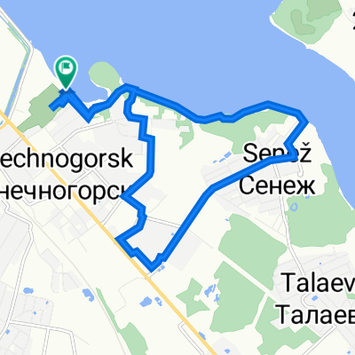
Вдоль Истринского водохранилища
A cycling route starting in Solnechnogorsk, Moscow Oblast, Russia.
Overview
About this route
From the Pokrovka station of the Leningrad direction to the Nakhabino railway station of the Kursk direction. Length 100 km.
The comfort of the route is not very high: there is off-road, in some places you have to go through the forest without paths, but most of the route runs near the picturesque shores of the reservoir, the contemplation of which will bring great pleasure to nature lovers. We reach the Pokrovka station by Tver electric train, then the route follows the highway along the dacha settlement, past Rakhmanovo to the village of Barskoe-Melechkino, where the asphalt ends. Further, the route goes along forest trails and dirt roads past dachas, approaching the shoreline, to Shchekino and Ivanovskoe, from where we have to ride along wooded paths to the road. Then the asphalt begins, along which we ride to Buzharovo, where we can take a break on the picturesque bank of the Istra. Then there is a steep ascent from the valley of the Istra to Safontyevo, a forest path to Maksimovka, asphalt to the A-107 highway, and dirt roads through Lisavino to the 155 km marker. From the opposite side of the railway begins a winding path leading to Yeryomyevo. From Yeryomyevo we go along the dirt road to Khovanskoe, and then through dacha settlements – to the northern edge of the village of Dedovo-Talyzino. From here by highway to Nakhabino station, and by electric train to Moscow. (cloned from route 3219789)- -:--
- Duration
- 97.8 km
- Distance
- 272 m
- Ascent
- 300 m
- Descent
- ---
- Avg. speed
- ---
- Max. altitude

Continue with Bikemap
Use, edit, or download this cycling route
You would like to ride Вдоль Истринского водохранилища or customize it for your own trip? Here is what you can do with this Bikemap route:
Free features
- Save this route as favorite or in collections
- Copy & plan your own version of this route
- Split it into stages to create a multi-day tour
- Sync your route with Garmin or Wahoo
Premium features
Free trial for 3 days, or one-time payment. More about Bikemap Premium.
- Navigate this route on iOS & Android
- Export a GPX / KML file of this route
- Create your custom printout (try it for free)
- Download this route for offline navigation
Discover more Premium features.
Get Bikemap PremiumFrom our community
Other popular routes starting in Solnechnogorsk
 Вертлинская улица, Солнечногорск до Вертлинская улица, Солнечногорск
- Distance
- 2.8 km
- Ascent
- 18 m
- Descent
- 23 m
- Location
- Solnechnogorsk, Moscow Oblast, Russia
 Вертлинская улица, Солнечногорск до Вертлинская улица, Солнечногорск
- Distance
- 10.7 km
- Ascent
- 112 m
- Descent
- 117 m
- Location
- Solnechnogorsk, Moscow Oblast, Russia
 От Советская улица, Солнечногорск до 46К-0270, Солнечногорск
- Distance
- 17.2 km
- Ascent
- 147 m
- Descent
- 133 m
- Location
- Solnechnogorsk, Moscow Oblast, Russia
 Сенежская улица, Солнечногорск до Банковская улица, Солнечногорск
- Distance
- 7.8 km
- Ascent
- 43 m
- Descent
- 46 m
- Location
- Solnechnogorsk, Moscow Oblast, Russia
 Вдоль Истринского водохранилища
- Distance
- 97.8 km
- Ascent
- 272 m
- Descent
- 300 m
- Location
- Solnechnogorsk, Moscow Oblast, Russia
 Солнечная аллея
- Distance
- 11.3 km
- Ascent
- 38 m
- Descent
- 42 m
- Location
- Solnechnogorsk, Moscow Oblast, Russia
 Super Enduro (v jopu shosse!)
- Distance
- 36.8 km
- Ascent
- 265 m
- Descent
- 265 m
- Location
- Solnechnogorsk, Moscow Oblast, Russia
 Solnechnogorsk - Klin
- Distance
- 36.6 km
- Ascent
- 208 m
- Descent
- 236 m
- Location
- Solnechnogorsk, Moscow Oblast, Russia
Open it in the app