
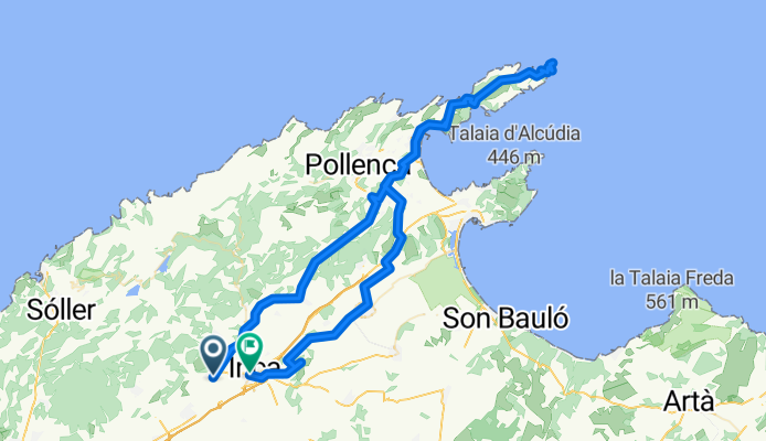
Station Lioseta - Cap de Formentor - station Inca
A cycling route starting in Lloseta, Balearic Islands, Spain.
Overview
About this route
Vanaf treinstation Lioseta naar Cap de Formentor en via Puig de Son Sastre naar treinstation Inca
- -:--
- Duration
- 111.3 km
- Distance
- 1,009 m
- Ascent
- 1,025 m
- Descent
- ---
- Avg. speed
- ---
- Avg. speed
Route quality
Waytypes & surfaces along the route
Waytypes
Road
51.7 km
(46 %)
Quiet road
44.5 km
(40 %)
Surfaces
Paved
105.5 km
(95 %)
Unpaved
0.1 km
(<1 %)
Asphalt
104.9 km
(94 %)
Paving stones
0.6 km
(<1 %)
Continue with Bikemap
Use, edit, or download this cycling route
You would like to ride Station Lioseta - Cap de Formentor - station Inca or customize it for your own trip? Here is what you can do with this Bikemap route:
Free features
- Save this route as favorite or in collections
- Copy & plan your own version of this route
- Split it into stages to create a multi-day tour
- Sync your route with Garmin or Wahoo
Premium features
Free trial for 3 days, or one-time payment. More about Bikemap Premium.
- Navigate this route on iOS & Android
- Export a GPX / KML file of this route
- Create your custom printout (try it for free)
- Download this route for offline navigation
Discover more Premium features.
Get Bikemap PremiumFrom our community
Other popular routes starting in Lloseta
 RR Lloseta Alaro Puig Caimari 90k 1800hm
- Distance
- 88.9 km
- Ascent
- 3,233 m
- Descent
- 3,230 m
- Location
- Lloseta, Balearic Islands, Spain
 Lloseta-Mancor-Caimiri-GorgBlau-Fornalutx-Soller-ColDeSoller-Bunyola-SantaMaria-Lloseta
- Distance
- 96.8 km
- Ascent
- 2,793 m
- Descent
- 2,794 m
- Location
- Lloseta, Balearic Islands, Spain
 Peguera -> Palma -> (Zug) -> Lloseta -> Sóller -> Peguera
- Distance
- 137 km
- Ascent
- 3,600 m
- Descent
- 3,674 m
- Location
- Lloseta, Balearic Islands, Spain
 Lloseta-Pollenca-Alcudia-Sa Pobla-Inca-Lloseta (71km)
- Distance
- 70.9 km
- Ascent
- 315 m
- Descent
- 316 m
- Location
- Lloseta, Balearic Islands, Spain
 Mallorca: Lloseta-Lluc-Gorg Blau-Inca
- Distance
- 60 km
- Ascent
- 1,448 m
- Descent
- 1,464 m
- Location
- Lloseta, Balearic Islands, Spain
 Lloseta - Marratxinet - Camí Vell de Muro
- Distance
- 41 km
- Ascent
- 216 m
- Descent
- 216 m
- Location
- Lloseta, Balearic Islands, Spain
 Mallorca: Lloseta-Biniagual-Binissalem-Alaró-Coanegra-Santa Maria
- Distance
- 36.8 km
- Ascent
- 349 m
- Descent
- 360 m
- Location
- Lloseta, Balearic Islands, Spain
 Lloseta-Mancor-Caimari-CollDePuigMajor-Fernalutx-Soller-Bunyola-Orient-Lloseta
- Distance
- 93.1 km
- Ascent
- 2,933 m
- Descent
- 2,697 m
- Location
- Lloseta, Balearic Islands, Spain
Open it in the app