Murowaniec + Dolina Chochołowska + Butorowy Wierch i Gubałówka
A cycling route starting in Poronin, Lesser Poland Voivodeship, Poland.
Overview
About this route
Climb from Murzasichle to the Murowaniec shelter without stopping and without pushing. The terrain section is easy from a conditioning standpoint but quite challenging technically due to the stony surface. Difficulty scale: 6 (0-10). (For comparison, I recommend the route to the Chatka at Zielone Pleso, there - 9). The black trail - "Droga pod reglami" is a very pleasant and easy section. Dolina Chochołowska: long and flat, then a slight incline and at the end a bit uphill, beautiful views! The ascent to Mietłówka is quite exhausting, everywhere to climb. The black trail to Gubałówka is easy but not very interesting. From Gubałówka, a nice descent, after that only asphalt. The best descent (20%) through Leszczyny.
- -:--
- Duration
- 83.5 km
- Distance
- 1,497 m
- Ascent
- 1,496 m
- Descent
- ---
- Avg. speed
- ---
- Max. altitude
Route highlights
Points of interest along the route

Photo after 9.9 km
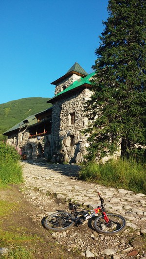
Hala Gąsienicowa, Murowaniec

Point of interest after 10.1 km
Schronisko PTTK Murowaniec 1505 m n.p.m. 06.08.15, 07:00

Photo after 10.1 km

Photo after 10.9 km
na zjeździe

Photo after 12.1 km
zjazd cd

Photo after 15.9 km
początek czarnego szlaku 966 m n.p.m.

Photo after 18.1 km
Toporowa Cyrhla

Point of interest after 24 km
Wielka Krokiew

Photo after 25.4 km
na czarnym szlaku "pod reglami"

Photo after 28.5 km
widok na Gubałówkę

Photo after 35.1 km
Lejowy Potok

Photo after 38.1 km
Dolina Chochołowska

Accommodation after 42.9 km
Schronisko Górskie PTTK na Polanie Chochołowskiej 1146 m n.p.m.

Point of interest after 43 km

Photo after 43 km
Kominiarski Wierch

Photo after 43.4 km
szałasy

Photo after 48 km
kolejka turystyczna

Photo after 49.6 km
Siwa Polana

Photo after 52.4 km

Photo after 54.4 km

Photo after 55.7 km

Photo after 55.7 km

Point of interest after 56.3 km
Mietłówka

Point of interest after 56.3 km

Photo after 56.4 km
szałasy na Mietłówce

Point of interest after 56.9 km

Photo after 56.9 km

Point of interest after 60.1 km
Butorowy Wierch 1160 m n.p.m.

Point of interest after 61.5 km

Photo after 62.2 km
Giewont z Gubałówki

Point of interest after 65.1 km
Furmanów, widok na Giewont

Photo after 77.8 km
Poronin

Accommodation after 83.4 km
u-gasienicy.pl
Continue with Bikemap
Use, edit, or download this cycling route
You would like to ride Murowaniec + Dolina Chochołowska + Butorowy Wierch i Gubałówka or customize it for your own trip? Here is what you can do with this Bikemap route:
Free features
- Save this route as favorite or in collections
- Copy & plan your own version of this route
- Split it into stages to create a multi-day tour
- Sync your route with Garmin or Wahoo
Premium features
Free trial for 3 days, or one-time payment. More about Bikemap Premium.
- Navigate this route on iOS & Android
- Export a GPX / KML file of this route
- Create your custom printout (try it for free)
- Download this route for offline navigation
Discover more Premium features.
Get Bikemap PremiumFrom our community
Other popular routes starting in Poronin
 Ząb Gubałówka Butorowy Wierch Chochołowska
- Distance
- 42.3 km
- Ascent
- 717 m
- Descent
- 722 m
- Location
- Poronin, Lesser Poland Voivodeship, Poland
 asdsa
asdsa- Distance
- 38 km
- Ascent
- 576 m
- Descent
- 576 m
- Location
- Poronin, Lesser Poland Voivodeship, Poland
 Pętla - Harenda - Bukowina - Harenda
- Distance
- 35.5 km
- Ascent
- 576 m
- Descent
- 576 m
- Location
- Poronin, Lesser Poland Voivodeship, Poland
 ZAKOPANE 2011: Pętla - Harenda - Rafaczowki - Gubałówka - Dzianisz - Witów - Kościelisko - Zakopane - Harenda
- Distance
- 34.5 km
- Ascent
- 573 m
- Descent
- 576 m
- Location
- Poronin, Lesser Poland Voivodeship, Poland
 Murowaniec + Dolina Chochołowska + Butorowy Wierch i Gubałówka
- Distance
- 83.5 km
- Ascent
- 1,497 m
- Descent
- 1,496 m
- Location
- Poronin, Lesser Poland Voivodeship, Poland
 Poronin-Małe Ciche-Błociska-Zazadnia-Brzeziny-Murzasichle-Budzowy Wierch-Majerczykówka-Poronin
- Distance
- 20.4 km
- Ascent
- 301 m
- Descent
- 299 m
- Location
- Poronin, Lesser Poland Voivodeship, Poland
 Murzasichle w okolicach
- Distance
- 25.2 km
- Ascent
- 518 m
- Descent
- 518 m
- Location
- Poronin, Lesser Poland Voivodeship, Poland
 Murzasichle Małe Ciche
- Distance
- 15.2 km
- Ascent
- 237 m
- Descent
- 242 m
- Location
- Poronin, Lesser Poland Voivodeship, Poland
Open it in the app


