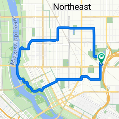
B2B 00003: 55114 to 55407 via Franklin, Greenway
A cycling route starting in Lauderdale, Minnesota, United States.
Overview
About this route
- -:--
- Duration
- 8.7 km
- Distance
- 43 m
- Ascent
- 52 m
- Descent
- ---
- Avg. speed
- 270 m
- Max. altitude
Route quality
Waytypes & surfaces along the route
Waytypes
Quiet road
4.1 km
(47 %)
Cycleway
3.4 km
(39 %)
Surfaces
Paved
7.7 km
(88 %)
Asphalt
5.2 km
(60 %)
Concrete
2.4 km
(27 %)
Route highlights
Points of interest along the route
Point of interest after 8.2 km
Use the sidewalk for a block or two where 10th Ave briefly disappears alongside Powderhorn Park.
Continue with Bikemap
Use, edit, or download this cycling route
You would like to ride B2B 00003: 55114 to 55407 via Franklin, Greenway or customize it for your own trip? Here is what you can do with this Bikemap route:
Free features
- Save this route as favorite or in collections
- Copy & plan your own version of this route
- Sync your route with Garmin or Wahoo
Premium features
Free trial for 3 days, or one-time payment. More about Bikemap Premium.
- Navigate this route on iOS & Android
- Export a GPX / KML file of this route
- Create your custom printout (try it for free)
- Download this route for offline navigation
Discover more Premium features.
Get Bikemap PremiumFrom our community
Other popular routes starting in Lauderdale
 12th Ave NE, Minneapolis to 12th Ave NE, Minneapolis
- Distance
- 9.2 km
- Ascent
- 25 m
- Descent
- 36 m
- Location
- Lauderdale, Minnesota, United States
 B2B00900 55113>55104 via Fairview Av, Como Av
- Distance
- 10.1 km
- Ascent
- 22 m
- Descent
- 36 m
- Location
- Lauderdale, Minnesota, United States
 To Bike Camping!
- Distance
- 79.5 km
- Ascent
- 253 m
- Descent
- 283 m
- Location
- Lauderdale, Minnesota, United States
 B2B00051 55108>55345 via CLT, SWLRT Trls
- Distance
- 27.8 km
- Ascent
- 128 m
- Descent
- 94 m
- Location
- Lauderdale, Minnesota, United States
 Fort Snelling Loop
- Distance
- 20.9 km
- Ascent
- 169 m
- Descent
- 154 m
- Location
- Lauderdale, Minnesota, United States
 From Minneapolis to Saint Paul
- Distance
- 8.8 km
- Ascent
- 57 m
- Descent
- 49 m
- Location
- Lauderdale, Minnesota, United States
 Surley Downtown Route
- Distance
- 67.1 km
- Ascent
- 508 m
- Descent
- 509 m
- Location
- Lauderdale, Minnesota, United States
 B2B00715 55406 > 55402 via Midtown Greenway, Park Ave
- Distance
- 9 km
- Ascent
- 15 m
- Descent
- 3 m
- Location
- Lauderdale, Minnesota, United States
Open it in the app

