Val di Sole - Ossana Caldes
A cycling route starting in Ossana, Trentino-Alto Adige, Italy.
Overview
About this route
Nuova gita relax nella nostra amata Val di Sole
- -:--
- Duration
- 42.8 km
- Distance
- 387 m
- Ascent
- 388 m
- Descent
- ---
- Avg. speed
- ---
- Avg. speed
Route quality
Waytypes & surfaces along the route
Waytypes
Cycleway
25.6 km
(60 %)
Quiet road
9.5 km
(22 %)
Surfaces
Paved
36.8 km
(86 %)
Unpaved
0.8 km
(2 %)
Asphalt
33.5 km
(78 %)
Paved (undefined)
2.6 km
(6 %)
Continue with Bikemap
Use, edit, or download this cycling route
You would like to ride Val di Sole - Ossana Caldes or customize it for your own trip? Here is what you can do with this Bikemap route:
Free features
- Save this route as favorite or in collections
- Copy & plan your own version of this route
- Sync your route with Garmin or Wahoo
Premium features
Free trial for 3 days, or one-time payment. More about Bikemap Premium.
- Navigate this route on iOS & Android
- Export a GPX / KML file of this route
- Create your custom printout (try it for free)
- Download this route for offline navigation
Discover more Premium features.
Get Bikemap PremiumFrom our community
Other popular routes starting in Ossana
- Epic Trail Grande Guerra - MowiBike
- Distance
- 59.4 km
- Ascent
- 0 m
- Descent
- 0 m
- Location
- Ossana, Trentino-Alto Adige, Italy
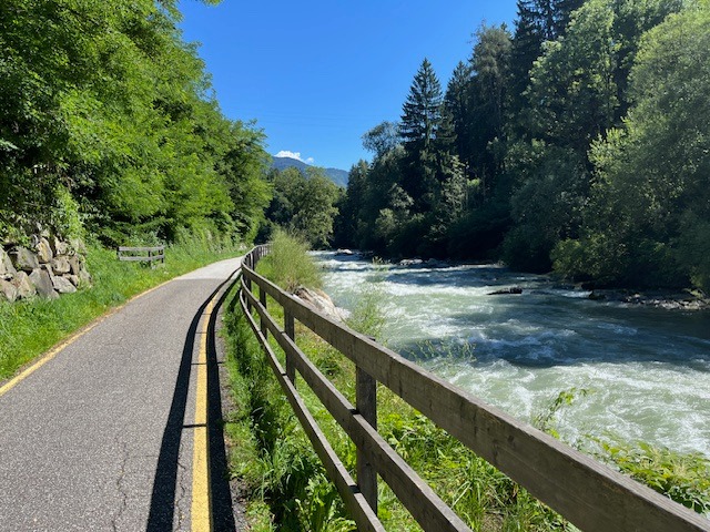
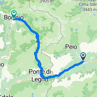
- Val di Sole Ossana - Caldes
- Distance
- 41.7 km
- Ascent
- 385 m
- Descent
- 389 m
- Location
- Ossana, Trentino-Alto Adige, Italy
- Ossana - Caldes
- Distance
- 42.2 km
- Ascent
- 588 m
- Descent
- 593 m
- Location
- Ossana, Trentino-Alto Adige, Italy
- Val di Sole - Ossana Caldes
- Distance
- 42.8 km
- Ascent
- 387 m
- Descent
- 388 m
- Location
- Ossana, Trentino-Alto Adige, Italy
- Ossana- Caldes 08.08.2023
- Distance
- 41.4 km
- Ascent
- 639 m
- Descent
- 634 m
- Location
- Ossana, Trentino-Alto Adige, Italy
- Dag 3
- Distance
- 70.5 km
- Ascent
- 2,007 m
- Descent
- 2,330 m
- Location
- Ossana, Trentino-Alto Adige, Italy
- Ossana - Tonalle - Gavia - Bormio
- Distance
- 67.2 km
- Ascent
- 2,268 m
- Descent
- 2,024 m
- Location
- Ossana, Trentino-Alto Adige, Italy
- Pejo - La strada militare
- Distance
- 38.3 km
- Ascent
- 1,037 m
- Descent
- 1,038 m
- Location
- Ossana, Trentino-Alto Adige, Italy
Open it in the app