

TARANDTER WALD
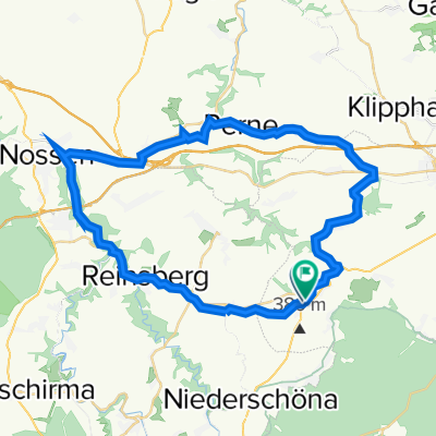
A cycling route starting in Niederschöna, Saxony, Germany.
Overview
About this route
im Tharandterwald & auf alter Eisenbahnstrecke,aber immer auf und ab
- -:--
- Duration
- 39.2 km
- Distance
- 474 m
- Ascent
- 491 m
- Descent
- ---
- Avg. speed
- 453 m
- Max. altitude

Route quality
Waytypes & surfaces along the route
Waytypes
Track
17.5 km
(45 %)
Quiet road
11.1 km
(28 %)
Surfaces
Paved
11.1 km
(28 %)
Unpaved
24.1 km
(62 %)
Gravel
11.7 km
(30 %)
Asphalt
10.4 km
(27 %)
Continue with Bikemap
Use, edit, or download this cycling route
You would like to ride TARANDTER WALD or customize it for your own trip? Here is what you can do with this Bikemap route:
Free features
- Save this route as favorite or in collections
- Copy & plan your own version of this route
- Sync your route with Garmin or Wahoo
Premium features
Free trial for 3 days, or one-time payment. More about Bikemap Premium.
- Navigate this route on iOS & Android
- Export a GPX / KML file of this route
- Create your custom printout (try it for free)
- Download this route for offline navigation
Discover more Premium features.
Get Bikemap PremiumFrom our community
Other popular routes starting in Niederschöna
 Naundorf -Talsperre Malter
- Distance
- 19.2 km
- Ascent
- 269 m
- Descent
- 291 m
- Location
- Niederschöna, Saxony, Germany
 Halsbrücke-Rothenfurth
- Distance
- 18.6 km
- Ascent
- 227 m
- Descent
- 227 m
- Location
- Niederschöna, Saxony, Germany
 Naundorf- Rechenberger Brauerei
- Distance
- 40.1 km
- Ascent
- 612 m
- Descent
- 378 m
- Location
- Niederschöna, Saxony, Germany
 Naundorf - Meilerplatz Tharndt - Grillenburg Naundorf
- Distance
- 29.9 km
- Ascent
- 395 m
- Descent
- 396 m
- Location
- Niederschöna, Saxony, Germany
 Dorfstraße 58, Halsbrücke nach Dorfstraße 58, Halsbrücke
- Distance
- 5.9 km
- Ascent
- 102 m
- Descent
- 98 m
- Location
- Niederschöna, Saxony, Germany
 obbad
obbad- Distance
- 30.4 km
- Ascent
- 213 m
- Descent
- 213 m
- Location
- Niederschöna, Saxony, Germany
 Nossen-Birkenhain-Runde
- Distance
- 41 km
- Ascent
- 301 m
- Descent
- 306 m
- Location
- Niederschöna, Saxony, Germany
 Rundtour zum Lipps Tullianfelsen (schöner Ausblick) und durch den Tharanter Wald zurück.
- Distance
- 21.3 km
- Ascent
- 239 m
- Descent
- 241 m
- Location
- Niederschöna, Saxony, Germany
Open it in the app