

Caminho Portugues 3. Etappe
A cycling route starting in Tomar, Santarém District, Portugal.
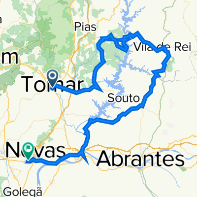
Overview
About this route
Tomar - Coimbra (cloned from route 3143568)
- -:--
- Duration
- 87.2 km
- Distance
- 784 m
- Ascent
- 762 m
- Descent
- ---
- Avg. speed
- ---
- Max. altitude

Route quality
Waytypes & surfaces along the route
Waytypes
Quiet road
31.4 km
(36 %)
Road
17.4 km
(20 %)
Surfaces
Paved
47.1 km
(54 %)
Unpaved
11.3 km
(13 %)
Asphalt
44.5 km
(51 %)
Unpaved (undefined)
6.1 km
(7 %)
Continue with Bikemap
Use, edit, or download this cycling route
You would like to ride Caminho Portugues 3. Etappe or customize it for your own trip? Here is what you can do with this Bikemap route:
Free features
- Save this route as favorite or in collections
- Copy & plan your own version of this route
- Split it into stages to create a multi-day tour
- Sync your route with Garmin or Wahoo
Premium features
Free trial for 3 days, or one-time payment. More about Bikemap Premium.
- Navigate this route on iOS & Android
- Export a GPX / KML file of this route
- Create your custom printout (try it for free)
- Download this route for offline navigation
Discover more Premium features.
Get Bikemap PremiumFrom our community
Other popular routes starting in Tomar
 Tomar - Prado - Ponte Peniche
- Distance
- 13.2 km
- Ascent
- 196 m
- Descent
- 202 m
- Location
- Tomar, Santarém District, Portugal
 Tomar-Barreiras-Zezere-Tomar
- Distance
- 40.2 km
- Ascent
- 438 m
- Descent
- 438 m
- Location
- Tomar, Santarém District, Portugal
 Ciloturismo pelas Aldeias Históricas Dia2/14
- Distance
- 63.9 km
- Ascent
- 513 m
- Descent
- 529 m
- Location
- Tomar, Santarém District, Portugal
 Tomar to Ansiao Day #4 March 23rd
- Distance
- 42.5 km
- Ascent
- 380 m
- Descent
- 240 m
- Location
- Tomar, Santarém District, Portugal
 Tomar Serra Agroal
- Distance
- 52.4 km
- Ascent
- 710 m
- Descent
- 703 m
- Location
- Tomar, Santarém District, Portugal
 Dia 07. Tomar - Coimbra
- Distance
- 87.1 km
- Ascent
- 664 m
- Descent
- 619 m
- Location
- Tomar, Santarém District, Portugal
 Rua da Hortá do Peru, Tomar à Rua Sub-Vila, Nazaré
- Distance
- 92.6 km
- Ascent
- 1,719 m
- Descent
- 1,759 m
- Location
- Tomar, Santarém District, Portugal
 Tomar - Vila de Rei - Constância - Entroncamento
- Distance
- 103.9 km
- Ascent
- 1,030 m
- Descent
- 1,048 m
- Location
- Tomar, Santarém District, Portugal
Open it in the app