

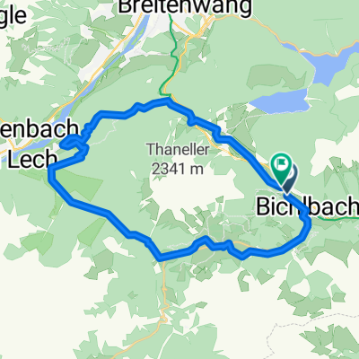
Planseerunde
A cycling route starting in Bichlbach, Tyrol, Austria.
Overview
About this route
from Bergfex
(cloned from route 3228347)
- -:--
- Duration
- 43.1 km
- Distance
- 395 m
- Ascent
- 395 m
- Descent
- ---
- Avg. speed
- ---
- Max. altitude
Continue with Bikemap
Use, edit, or download this cycling route
You would like to ride Planseerunde or customize it for your own trip? Here is what you can do with this Bikemap route:
Free features
- Save this route as favorite or in collections
- Copy & plan your own version of this route
- Sync your route with Garmin or Wahoo
Premium features
Free trial for 3 days, or one-time payment. More about Bikemap Premium.
- Navigate this route on iOS & Android
- Export a GPX / KML file of this route
- Create your custom printout (try it for free)
- Download this route for offline navigation
Discover more Premium features.
Get Bikemap PremiumFrom our community
Other popular routes starting in Bichlbach
 Etappe 2 Via Claudia Augusta Alpenüberquerung
- Distance
- 85.7 km
- Ascent
- 1,668 m
- Descent
- 1,863 m
- Location
- Bichlbach, Tyrol, Austria
 Bichlbach - Tour
- Distance
- 53.1 km
- Ascent
- 785 m
- Descent
- 785 m
- Location
- Bichlbach, Tyrol, Austria
 Almkopfbahn nach Almkopfbahn
- Distance
- 29.8 km
- Ascent
- 1,031 m
- Descent
- 1,037 m
- Location
- Bichlbach, Tyrol, Austria
 Namlossattel v. Bichlbach
- Distance
- 12.5 km
- Ascent
- 499 m
- Descent
- 211 m
- Location
- Bichlbach, Tyrol, Austria
 Planseerunde
- Distance
- 43.1 km
- Ascent
- 395 m
- Descent
- 395 m
- Location
- Bichlbach, Tyrol, Austria
 Bichelbach-Stanzach
- Distance
- 25.9 km
- Ascent
- 634 m
- Descent
- 691 m
- Location
- Bichlbach, Tyrol, Austria
 ehrwlder alm
- Distance
- 116.1 km
- Ascent
- 1,149 m
- Descent
- 1,375 m
- Location
- Bichlbach, Tyrol, Austria
 Rückfahrt Bichlbach
- Distance
- 146.1 km
- Ascent
- 1,218 m
- Descent
- 1,390 m
- Location
- Bichlbach, Tyrol, Austria
Open it in the app