
Fi-Gö, Heitersberg, Egelsee, Hasenberg, Bremgarten, Reuss
A cycling route starting in Künten, Canton of Aargau, Switzerland.
Overview
About this route
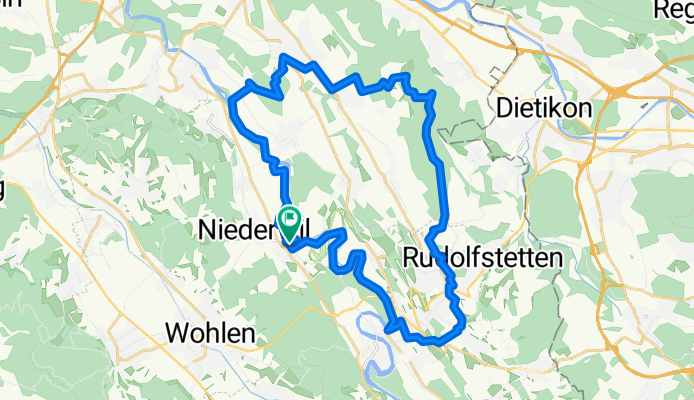
From Fi-Gö along the Reuss to Gnadenthal, continuing along the Reuss via Torfmoos/Weiher near Oberrohrdorf up to the Heitersberg. From there, the trails descend along Egelsee to Hasenberg. From then on, it's all downhill via Widen, Berikon, Zufikon down to the Reuss in Bremgarten, where we cross to the other bank over the bridge to return to Fi-Gö along winding trails beside the Reuss.
- -:--
- Duration
- 32.9 km
- Distance
- 481 m
- Ascent
- 484 m
- Descent
- ---
- Avg. speed
- ---
- Max. altitude

Continue with Bikemap
Use, edit, or download this cycling route
You would like to ride Fi-Gö, Heitersberg, Egelsee, Hasenberg, Bremgarten, Reuss or customize it for your own trip? Here is what you can do with this Bikemap route:
Free features
- Save this route as favorite or in collections
- Copy & plan your own version of this route
- Sync your route with Garmin or Wahoo
Premium features
Free trial for 3 days, or one-time payment. More about Bikemap Premium.
- Navigate this route on iOS & Android
- Export a GPX / KML file of this route
- Create your custom printout (try it for free)
- Download this route for offline navigation
Discover more Premium features.
Get Bikemap PremiumFrom our community
Other popular routes starting in Künten
 RR_NW_2_NW_2cKm_5THm
- Distance
- 200.3 km
- Ascent
- 4,694 m
- Descent
- 4,692 m
- Location
- Künten, Canton of Aargau, Switzerland
 ¿ˇ≠◊? nach ¿ˇ≠◊?
- Distance
- 11.4 km
- Ascent
- 222 m
- Descent
- 219 m
- Location
- Künten, Canton of Aargau, Switzerland
 Stetten-Niederwil-Waltenschwil-Muri
- Distance
- 20.4 km
- Ascent
- 178 m
- Descent
- 85 m
- Location
- Künten, Canton of Aargau, Switzerland
 2015-07-21
- Distance
- 23.9 km
- Ascent
- 338 m
- Descent
- 338 m
- Location
- Künten, Canton of Aargau, Switzerland
 Stetten - Muri
- Distance
- 22.4 km
- Ascent
- 216 m
- Descent
- 114 m
- Location
- Künten, Canton of Aargau, Switzerland
 Heitersberg - Hasenberg Runde
- Distance
- 23.6 km
- Ascent
- 409 m
- Descent
- 440 m
- Location
- Künten, Canton of Aargau, Switzerland
 NW_2_Morges_2025_V01
- Distance
- 197.3 km
- Ascent
- 1,701 m
- Descent
- 1,728 m
- Location
- Künten, Canton of Aargau, Switzerland
 RR_NW_2_ZH_ST_NW
- Distance
- 81.5 km
- Ascent
- 1,797 m
- Descent
- 1,781 m
- Location
- Künten, Canton of Aargau, Switzerland
Open it in the app