
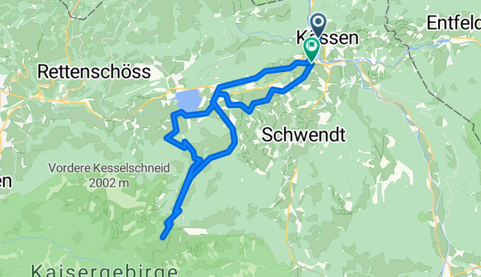
Kössen, Weißbach , Walchsee, Kössen-Runde
A cycling route starting in Kössen, Tyrol, Austria.
Overview
About this route
Start in Kössen at the cross-country ski center. Along the Ache to the golf course Over the hills to Walchsee, from there along the Weißbach towards Stripsenjoch. On the way back via Gwirchtalm to Walchsee at the "south shore" to cool down and then back to Kössen via Bichlach and the golf course.
- -:--
- Duration
- 38.3 km
- Distance
- 960 m
- Ascent
- 962 m
- Descent
- ---
- Avg. speed
- ---
- Max. altitude
Route quality
Waytypes & surfaces along the route
Waytypes
Track
20.3 km
(53 %)
Quiet road
14.9 km
(39 %)
Surfaces
Paved
17.2 km
(45 %)
Unpaved
20.3 km
(53 %)
Gravel
18.4 km
(48 %)
Asphalt
17.2 km
(45 %)
Continue with Bikemap
Use, edit, or download this cycling route
You would like to ride Kössen, Weißbach , Walchsee, Kössen-Runde or customize it for your own trip? Here is what you can do with this Bikemap route:
Free features
- Save this route as favorite or in collections
- Copy & plan your own version of this route
- Sync your route with Garmin or Wahoo
Premium features
Free trial for 3 days, or one-time payment. More about Bikemap Premium.
- Navigate this route on iOS & Android
- Export a GPX / KML file of this route
- Create your custom printout (try it for free)
- Download this route for offline navigation
Discover more Premium features.
Get Bikemap PremiumFrom our community
Other popular routes starting in Kössen
 Kössen Cafe Zacherl
- Distance
- 49.6 km
- Ascent
- 735 m
- Descent
- 733 m
- Location
- Kössen, Tyrol, Austria
 Kössen, Weißbach , Walchsee, Kössen-Runde
- Distance
- 38.3 km
- Ascent
- 960 m
- Descent
- 962 m
- Location
- Kössen, Tyrol, Austria
 Kössen - Kitzbühelhorn
- Distance
- 82.9 km
- Ascent
- 1,838 m
- Descent
- 1,958 m
- Location
- Kössen, Tyrol, Austria
 Zwei auf einen Schlag
- Distance
- 47.6 km
- Ascent
- 1,432 m
- Descent
- 1,432 m
- Location
- Kössen, Tyrol, Austria
 Kössen - Bayrisch-Zell - Kufstein - Kössen
- Distance
- 103.7 km
- Ascent
- 2,079 m
- Descent
- 2,223 m
- Location
- Kössen, Tyrol, Austria
 Rund um den Unterberg - Kössen
- Distance
- 57.2 km
- Ascent
- 605 m
- Descent
- 570 m
- Location
- Kössen, Tyrol, Austria
 Erl - Aschau - Kössen
- Distance
- 80.4 km
- Ascent
- 456 m
- Descent
- 456 m
- Location
- Kössen, Tyrol, Austria
 Bayr. Runde
- Distance
- 60.1 km
- Ascent
- 428 m
- Descent
- 428 m
- Location
- Kössen, Tyrol, Austria
Open it in the app