

Ruta Montecarmelo-El Pardo-Montecarmelo 21k (media maratón)
A cycling route starting in Las Tablas, Madrid, Spain.
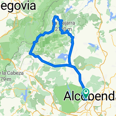
Overview
About this route
Posible ruta por el pardo sin excesivos desniveles y con buenas vistas durante la mayor parte del trayecto. Posible target Almost Man 2009
- -:--
- Duration
- 20.5 km
- Distance
- 149 m
- Ascent
- 156 m
- Descent
- ---
- Avg. speed
- 740 m
- Max. altitude
Route quality
Waytypes & surfaces along the route
Waytypes
Track
11.9 km
(58 %)
Path
4.5 km
(22 %)
Surfaces
Paved
2.7 km
(13 %)
Unpaved
9.6 km
(47 %)
Ground
7.2 km
(35 %)
Gravel
2.3 km
(11 %)
Continue with Bikemap
Use, edit, or download this cycling route
You would like to ride Ruta Montecarmelo-El Pardo-Montecarmelo 21k (media maratón) or customize it for your own trip? Here is what you can do with this Bikemap route:
Free features
- Save this route as favorite or in collections
- Copy & plan your own version of this route
- Sync your route with Garmin or Wahoo
Premium features
Free trial for 3 days, or one-time payment. More about Bikemap Premium.
- Navigate this route on iOS & Android
- Export a GPX / KML file of this route
- Create your custom printout (try it for free)
- Download this route for offline navigation
Discover more Premium features.
Get Bikemap PremiumFrom our community
Other popular routes starting in Las Tablas
 Navacerrada y Morcuera desde la Academia
- Distance
- 134.4 km
- Ascent
- 1,847 m
- Descent
- 1,846 m
- Location
- Las Tablas, Madrid, Spain
 Carril bici Colmenar-Soto
- Distance
- 35.2 km
- Ascent
- 354 m
- Descent
- 147 m
- Location
- Las Tablas, Madrid, Spain
 Ruta Valdelatas Escuela Triatlón HP-Saludando CLONED FROM ROUTE 449510
- Distance
- 19 km
- Ascent
- 237 m
- Descent
- 235 m
- Location
- Las Tablas, Madrid, Spain
 MADSEG19_TR1
- Distance
- 62.3 km
- Ascent
- 989 m
- Descent
- 510 m
- Location
- Las Tablas, Madrid, Spain
 Circuito Las Tablas - Sanchinarro
- Distance
- 10.6 km
- Ascent
- 182 m
- Descent
- 180 m
- Location
- Las Tablas, Madrid, Spain
 CLUB BTT HOLMES PLACE MIS. RUTA POR EL PARDO
- Distance
- 26.2 km
- Ascent
- 294 m
- Descent
- 294 m
- Location
- Las Tablas, Madrid, Spain
 Carril bici Colmenar
- Distance
- 60.4 km
- Ascent
- 395 m
- Descent
- 393 m
- Location
- Las Tablas, Madrid, Spain
 Anillo Verde Ciclista Madrid
- Distance
- 70.1 km
- Ascent
- 387 m
- Descent
- 390 m
- Location
- Las Tablas, Madrid, Spain
Open it in the app