
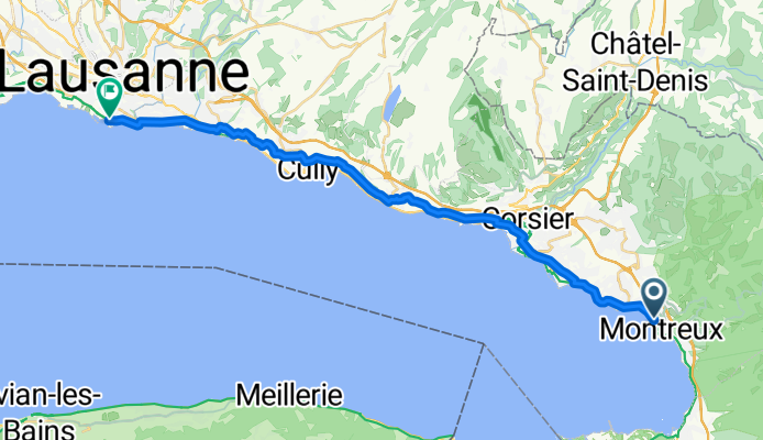
MONTREUX TO LAUSANNE
A cycling route starting in Montreux, Canton of Vaud, Switzerland.
Overview
About this route
BEIRANDO O LAGO
- -:--
- Duration
- 26.4 km
- Distance
- 362 m
- Ascent
- 356 m
- Descent
- ---
- Avg. speed
- ---
- Max. altitude

Route quality
Waytypes & surfaces along the route
Waytypes
Road
9.4 km
(35 %)
Busy road
7.9 km
(30 %)
Surfaces
Paved
21.1 km
(80 %)
Asphalt
18.8 km
(71 %)
Concrete
1.5 km
(6 %)
Continue with Bikemap
Use, edit, or download this cycling route
You would like to ride MONTREUX TO LAUSANNE or customize it for your own trip? Here is what you can do with this Bikemap route:
Free features
- Save this route as favorite or in collections
- Copy & plan your own version of this route
- Sync your route with Garmin or Wahoo
Premium features
Free trial for 3 days, or one-time payment. More about Bikemap Premium.
- Navigate this route on iOS & Android
- Export a GPX / KML file of this route
- Create your custom printout (try it for free)
- Download this route for offline navigation
Discover more Premium features.
Get Bikemap PremiumFrom our community
Other popular routes starting in Montreux
 Bonus ride!
- Distance
- 39.7 km
- Ascent
- 417 m
- Descent
- 417 m
- Location
- Montreux, Canton of Vaud, Switzerland
 Swiss Bike 6
- Distance
- 33.3 km
- Ascent
- 1,135 m
- Descent
- 1,138 m
- Location
- Montreux, Canton of Vaud, Switzerland
 Transalp Montreux-Menton
- Distance
- 617.5 km
- Ascent
- 11,634 m
- Descent
- 12,023 m
- Location
- Montreux, Canton of Vaud, Switzerland
 Giro antiorario Lago Ginevra
- Distance
- 176 km
- Ascent
- 457 m
- Descent
- 457 m
- Location
- Montreux, Canton of Vaud, Switzerland
 Kleiner Schlenker Montreux
- Distance
- 10.1 km
- Ascent
- 415 m
- Descent
- 398 m
- Location
- Montreux, Canton of Vaud, Switzerland
 Alpen 2015
- Distance
- 653.2 km
- Ascent
- 9,635 m
- Descent
- 10,025 m
- Location
- Montreux, Canton of Vaud, Switzerland
 00_Montreux_Pully
- Distance
- 26.1 km
- Ascent
- 400 m
- Descent
- 364 m
- Location
- Montreux, Canton of Vaud, Switzerland
 >Route des Grande Alpes< by C.K.
- Distance
- 732.7 km
- Ascent
- 12,097 m
- Descent
- 12,539 m
- Location
- Montreux, Canton of Vaud, Switzerland
Open it in the app