

VT 2015
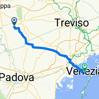
A cycling route starting in San Martino di Lupari, Veneto, Italy.
Overview
About this route
Avventura in MTB
Start 27 giugno 2015- -:--
- Duration
- 437.7 km
- Distance
- 4,273 m
- Ascent
- 4,274 m
- Descent
- ---
- Avg. speed
- ---
- Max. altitude

Continue with Bikemap
Use, edit, or download this cycling route
You would like to ride VT 2015 or customize it for your own trip? Here is what you can do with this Bikemap route:
Free features
- Save this route as favorite or in collections
- Copy & plan your own version of this route
- Split it into stages to create a multi-day tour
- Sync your route with Garmin or Wahoo
Premium features
Free trial for 3 days, or one-time payment. More about Bikemap Premium.
- Navigate this route on iOS & Android
- Export a GPX / KML file of this route
- Create your custom printout (try it for free)
- Download this route for offline navigation
Discover more Premium features.
Get Bikemap PremiumFrom our community
Other popular routes starting in San Martino di Lupari
 allenamento
- Distance
- 130.4 km
- Ascent
- 2,187 m
- Descent
- 2,183 m
- Location
- San Martino di Lupari, Veneto, Italy
 VTa7
VTa7- Distance
- 442 km
- Ascent
- 5,060 m
- Descent
- 5,059 m
- Location
- San Martino di Lupari, Veneto, Italy
 VT 2015
- Distance
- 437.7 km
- Ascent
- 4,273 m
- Descent
- 4,274 m
- Location
- San Martino di Lupari, Veneto, Italy
 1° GIORNO
- Distance
- 132 km
- Ascent
- 1,329 m
- Descent
- 758 m
- Location
- San Martino di Lupari, Veneto, Italy
 M1 Sportivando
- Distance
- 17.5 km
- Ascent
- 10 m
- Descent
- 14 m
- Location
- San Martino di Lupari, Veneto, Italy
 M057 run10k
- Distance
- 9.9 km
- Ascent
- 4 m
- Descent
- 4 m
- Location
- San Martino di Lupari, Veneto, Italy
 M4 Asolo per sentiero ezzelini
- Distance
- 48.1 km
- Ascent
- 186 m
- Descent
- 185 m
- Location
- San Martino di Lupari, Veneto, Italy
 8. Tag
- Distance
- 53.4 km
- Ascent
- 10 m
- Descent
- 46 m
- Location
- San Martino di Lupari, Veneto, Italy
Open it in the app