

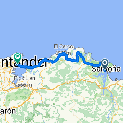
Recording from 24 augustus 13:35
A cycling route starting in Santoña, Cantabria, Spain.
Overview
About this route
Santona, Cantabria
- 2 h 54 min
- Duration
- 10.9 km
- Distance
- 552 m
- Ascent
- 550 m
- Descent
- 3.8 km/h
- Avg. speed
- ---
- Max. altitude
Route highlights
Points of interest along the route

Point of interest after 1 km
Continue with Bikemap
Use, edit, or download this cycling route
You would like to ride Recording from 24 augustus 13:35 or customize it for your own trip? Here is what you can do with this Bikemap route:
Free features
- Save this route as favorite or in collections
- Copy & plan your own version of this route
- Sync your route with Garmin or Wahoo
Premium features
Free trial for 3 days, or one-time payment. More about Bikemap Premium.
- Navigate this route on iOS & Android
- Export a GPX / KML file of this route
- Create your custom printout (try it for free)
- Download this route for offline navigation
Discover more Premium features.
Get Bikemap PremiumFrom our community
Other popular routes starting in Santoña
 Paseo rápido en Santoña
- Distance
- 10.5 km
- Ascent
- 44 m
- Descent
- 44 m
- Location
- Santoña, Cantabria, Spain
 Ampuero - Seña - Liendo
- Distance
- 30 km
- Ascent
- 554 m
- Descent
- 554 m
- Location
- Santoña, Cantabria, Spain
 Lar_Inv
- Distance
- 69.9 km
- Ascent
- 797 m
- Descent
- 797 m
- Location
- Santoña, Cantabria, Spain
 Recording from 24 augustus 13:35
- Distance
- 10.9 km
- Ascent
- 552 m
- Descent
- 550 m
- Location
- Santoña, Cantabria, Spain
 Tomarrabaketal 3.1
- Distance
- 55 km
- Ascent
- 411 m
- Descent
- 416 m
- Location
- Santoña, Cantabria, Spain
 Santoña - Santander
- Distance
- 43.1 km
- Ascent
- 286 m
- Descent
- 284 m
- Location
- Santoña, Cantabria, Spain
 repe
repe- Distance
- 76.4 km
- Ascent
- 659 m
- Descent
- 659 m
- Location
- Santoña, Cantabria, Spain
 Tomarrabaketak 3.2
- Distance
- 61.5 km
- Ascent
- 410 m
- Descent
- 414 m
- Location
- Santoña, Cantabria, Spain
Open it in the app