

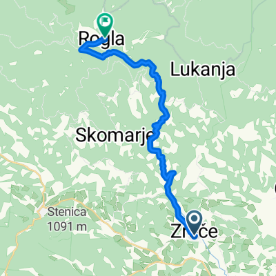
PT 1.dan: Bellevue - TK Pačnik (Resnik)
A cycling route starting in Zreče, Zreče Municipality, Slovenia.
Overview
About this route
1 dan trase Pohorske trasverzale KDBK.
- -:--
- Duration
- 44.7 km
- Distance
- 914 m
- Ascent
- 836 m
- Descent
- ---
- Avg. speed
- ---
- Max. altitude

Route quality
Waytypes & surfaces along the route
Waytypes
Track
17.4 km
(39 %)
Road
14.8 km
(33 %)
Quiet road
12.5 km
(28 %)
Surfaces
Paved
17.9 km
(40 %)
Unpaved
23.2 km
(52 %)
Gravel
16.5 km
(37 %)
Asphalt
9.4 km
(21 %)
Continue with Bikemap
Use, edit, or download this cycling route
You would like to ride PT 1.dan: Bellevue - TK Pačnik (Resnik) or customize it for your own trip? Here is what you can do with this Bikemap route:
Free features
- Save this route as favorite or in collections
- Copy & plan your own version of this route
- Sync your route with Garmin or Wahoo
Premium features
Free trial for 3 days, or one-time payment. More about Bikemap Premium.
- Navigate this route on iOS & Android
- Export a GPX / KML file of this route
- Create your custom printout (try it for free)
- Download this route for offline navigation
Discover more Premium features.
Get Bikemap PremiumFrom our community
Other popular routes starting in Zreče
 stranice-vitanje-paški kozjak-dobrna-socka-stranice
- Distance
- 35.5 km
- Ascent
- 868 m
- Descent
- 869 m
- Location
- Zreče, Zreče Municipality, Slovenia
 Zreče - Rogla
- Distance
- 16.7 km
- Ascent
- 1,078 m
- Descent
- 0 m
- Location
- Zreče, Zreče Municipality, Slovenia
 Zreče - Rogla -Zreče
- Distance
- 40.2 km
- Ascent
- 1,115 m
- Descent
- 1,118 m
- Location
- Zreče, Zreče Municipality, Slovenia
 Radana vas - Golek
- Distance
- 15.1 km
- Ascent
- 386 m
- Descent
- 386 m
- Location
- Zreče, Zreče Municipality, Slovenia
 Krožna čez Paški Kozjak
- Distance
- 61.8 km
- Ascent
- 1,050 m
- Descent
- 1,050 m
- Location
- Zreče, Zreče Municipality, Slovenia
 Zreče-Sv.Vid-Zreče
- Distance
- 20.8 km
- Ascent
- 499 m
- Descent
- 496 m
- Location
- Zreče, Zreče Municipality, Slovenia
 Zreče-Rogla-1
- Distance
- 43.4 km
- Ascent
- 1,175 m
- Descent
- 1,175 m
- Location
- Zreče, Zreče Municipality, Slovenia
 Krožna po smeri Padeški vrh-Planina na Pohorju-Cezlak
- Distance
- 29.8 km
- Ascent
- 869 m
- Descent
- 867 m
- Location
- Zreče, Zreče Municipality, Slovenia
Open it in the app