

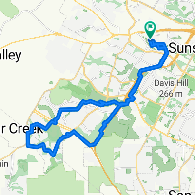
Sunset Valley to CLEAResult
A cycling route starting in Barton Creek, Texas, United States.
Overview
About this route
Start at Escarpment Blvd and Convict-Hill Rd.
East on Convict-Hill Rd to Brodie Ln
Left on Brodie Ln
Right on Ernest Robles Way
Right on Jones Rd
left on Pack Saddle Pass
Pack Saddle Pass becomes Victory Dr
Left on Panther Trail
Right on S Lamar Blvd
Left onto Bluebonnet Ln
Bluebonnet Ln becomes Melridge Pl
Right on Robert E Lee Rd
Left on Barton Springs Rd
Merges to Mopac Service Rd
Right on Rollingwood Dr
Straight onto Old Walsh Tarlton
left on Walsh Tarlton Ln
Right on Pinnacle Rd
Left on Westbank Dr
CLEAResult on Left
- -:--
- Duration
- 21.3 km
- Distance
- 124 m
- Ascent
- 137 m
- Descent
- ---
- Avg. speed
- ---
- Max. altitude
Route quality
Waytypes & surfaces along the route
Waytypes
Road
14.3 km
(67 %)
Access road
1.3 km
(6 %)
Surfaces
Paved
17.7 km
(83 %)
Asphalt
17 km
(80 %)
Concrete
0.6 km
(3 %)
Undefined
3.6 km
(17 %)
Continue with Bikemap
Use, edit, or download this cycling route
You would like to ride Sunset Valley to CLEAResult or customize it for your own trip? Here is what you can do with this Bikemap route:
Free features
- Save this route as favorite or in collections
- Copy & plan your own version of this route
- Sync your route with Garmin or Wahoo
Premium features
Free trial for 3 days, or one-time payment. More about Bikemap Premium.
- Navigate this route on iOS & Android
- Export a GPX / KML file of this route
- Create your custom printout (try it for free)
- Download this route for offline navigation
Discover more Premium features.
Get Bikemap PremiumFrom our community
Other popular routes starting in Barton Creek
 Driftwood Loop
- Distance
- 87.5 km
- Ascent
- 449 m
- Descent
- 453 m
- Location
- Barton Creek, Texas, United States
 High-speed route in Austin
- Distance
- 29.1 km
- Ascent
- 245 m
- Descent
- 246 m
- Location
- Barton Creek, Texas, United States
 Austin - William Cannon Dr - Costco - Mopac Cycling Path
- Distance
- 19.7 km
- Ascent
- 93 m
- Descent
- 183 m
- Location
- Barton Creek, Texas, United States
 5410 Wolf Run, Austin to 5409 Wolf Run, Austin
- Distance
- 35.8 km
- Ascent
- 842 m
- Descent
- 842 m
- Location
- Barton Creek, Texas, United States
 Fitzhugh Rd Loop
- Distance
- 69 km
- Ascent
- 386 m
- Descent
- 385 m
- Location
- Barton Creek, Texas, United States
 Practice? We talking bout practice
- Distance
- 30.7 km
- Ascent
- 401 m
- Descent
- 403 m
- Location
- Barton Creek, Texas, United States
 Slow ride in Austin
- Distance
- 44 km
- Ascent
- 358 m
- Descent
- 350 m
- Location
- Barton Creek, Texas, United States
 Home route with Cuernavaca loop
- Distance
- 38.9 km
- Ascent
- 778 m
- Descent
- 791 m
- Location
- Barton Creek, Texas, United States
Open it in the app