
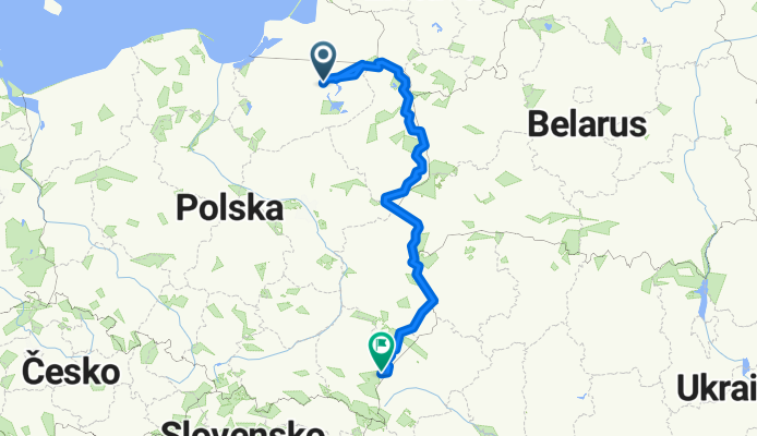
East_Poland_2015
A cycling route starting in Kętrzyn, Warmian-Masurian Voivodeship, Poland.
Overview
About this route
Wyprawa rowerowa Małgosi i Bodka. Sierpień 2015.
- -:--
- Duration
- 1,037.6 km
- Distance
- 108 m
- Ascent
- 81 m
- Descent
- ---
- Avg. speed
- ---
- Max. altitude

Route quality
Waytypes & surfaces along the route
Waytypes
Road
321.6 km
(31 %)
Quiet road
186.8 km
(18 %)
Surfaces
Paved
674.4 km
(65 %)
Unpaved
166 km
(16 %)
Asphalt
653.7 km
(63 %)
Gravel
114.1 km
(11 %)
Continue with Bikemap
Use, edit, or download this cycling route
You would like to ride East_Poland_2015 or customize it for your own trip? Here is what you can do with this Bikemap route:
Free features
- Save this route as favorite or in collections
- Copy & plan your own version of this route
- Split it into stages to create a multi-day tour
- Sync your route with Garmin or Wahoo
Premium features
Free trial for 3 days, or one-time payment. More about Bikemap Premium.
- Navigate this route on iOS & Android
- Export a GPX / KML file of this route
- Create your custom printout (try it for free)
- Download this route for offline navigation
Discover more Premium features.
Get Bikemap PremiumFrom our community
Other popular routes starting in Kętrzyn
 Masuren IV
- Distance
- 41.1 km
- Ascent
- 171 m
- Descent
- 141 m
- Location
- Kętrzyn, Warmian-Masurian Voivodeship, Poland
 Kaszubska 1, Kętrzyn do Kazimierza Wielkiego 12A, Kętrzyn
- Distance
- 2.2 km
- Ascent
- 17 m
- Descent
- 5 m
- Location
- Kętrzyn, Warmian-Masurian Voivodeship, Poland
 Stańczyki dzień I
- Distance
- 59.7 km
- Ascent
- 205 m
- Descent
- 175 m
- Location
- Kętrzyn, Warmian-Masurian Voivodeship, Poland
 2013.07.01
- Distance
- 28.8 km
- Ascent
- 160 m
- Descent
- 174 m
- Location
- Kętrzyn, Warmian-Masurian Voivodeship, Poland
 Ketrzyn - Mragowo
- Distance
- 48.5 km
- Ascent
- 253 m
- Descent
- 225 m
- Location
- Kętrzyn, Warmian-Masurian Voivodeship, Poland
 MasurenRad2 Ketrzyn-Mragowo
- Distance
- 53.1 km
- Ascent
- 250 m
- Descent
- 211 m
- Location
- Kętrzyn, Warmian-Masurian Voivodeship, Poland
 East_Poland_2015
- Distance
- 1,037.6 km
- Ascent
- 108 m
- Descent
- 81 m
- Location
- Kętrzyn, Warmian-Masurian Voivodeship, Poland
 Masuren III
- Distance
- 61.6 km
- Ascent
- 192 m
- Descent
- 169 m
- Location
- Kętrzyn, Warmian-Masurian Voivodeship, Poland
Open it in the app