

Ötztal Radmarathon
A cycling route starting in Solden, Tyrol, Austria.
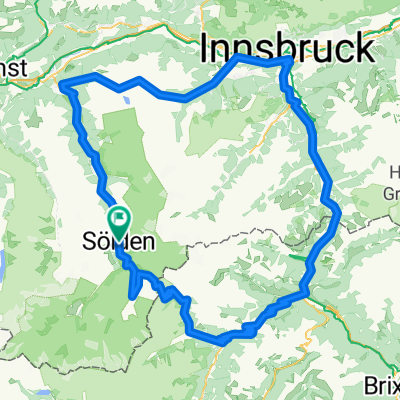
Overview
About this route
238 km, 5500 méter szint emelkedés
Útvonal: Sölden (1.377 m) – Längenfeld – Umhausen – Oetz (820 m) – Kühtai (2.020 m) – Kematen (610 m) – Völs – Innsbruck (600 m) - Sonnenburgerhof – Schönberg – Matrei am Brenner – Steinach am Brenner – Gries a. Brenner – Brenner (1.377 m) – Sterzing – Jaufenpass (2.090 m) – St. Leonhard im Passeiertal – Timmelsjoch (2.509 m) – Sölden (1.377 m). Alternatív útvonal: Sölden (1.377 m) – Ötz (820 m) – Kühtai (2.020 m – Labe Station bei km 51) – Kematen – Inzing- Hatting – Pfaffenhofen – Rietz – Stams (refreshment station at km 100) – Silz – Haiming – Höpperg (1.024 m) – Sattele (1.676 m – (1,676 m – refreshment station at km 119) – Ochsengarten – Ötz (820 m) – Östen (1,676 m – refreshment station at km 137) – Längenfeld (1.200 m) – Sölden (1.377 m).- -:--
- Duration
- 225.1 km
- Distance
- 4,777 m
- Ascent
- 4,788 m
- Descent
- ---
- Avg. speed
- ---
- Max. altitude

Route quality
Waytypes & surfaces along the route
Waytypes
Busy road
152.6 km
(68 %)
Quiet road
20 km
(9 %)
Surfaces
Paved
186 km
(83 %)
Unpaved
12.2 km
(5 %)
Asphalt
185.5 km
(82 %)
Ground
4.6 km
(2 %)
Continue with Bikemap
Use, edit, or download this cycling route
You would like to ride Ötztal Radmarathon or customize it for your own trip? Here is what you can do with this Bikemap route:
Free features
- Save this route as favorite or in collections
- Copy & plan your own version of this route
- Split it into stages to create a multi-day tour
- Sync your route with Garmin or Wahoo
Premium features
Free trial for 3 days, or one-time payment. More about Bikemap Premium.
- Navigate this route on iOS & Android
- Export a GPX / KML file of this route
- Create your custom printout (try it for free)
- Download this route for offline navigation
Discover more Premium features.
Get Bikemap PremiumFrom our community
Other popular routes starting in Solden
 Erst zur Pollesalm (leider schon geschlossen) und dann zur Feuersteinhütte
- Distance
- 13.4 km
- Ascent
- 622 m
- Descent
- 627 m
- Location
- Solden, Tyrol, Austria
 Ötztaler Radmarathon
- Distance
- 224.9 km
- Ascent
- 7,087 m
- Descent
- 6,581 m
- Location
- Solden, Tyrol, Austria
 Sölden, Rettenbachferner ( höchster Punkt 2800 m )
- Distance
- 28.7 km
- Ascent
- 1,460 m
- Descent
- 1,452 m
- Location
- Solden, Tyrol, Austria
 Oetztaler Radmarathon
- Distance
- 226.6 km
- Ascent
- 6,958 m
- Descent
- 6,424 m
- Location
- Solden, Tyrol, Austria
 Vor dem großen Regen noch mal nach Sölden hoch
- Distance
- 25.2 km
- Ascent
- 265 m
- Descent
- 266 m
- Location
- Solden, Tyrol, Austria
 Ötztaler Radmarathon
- Distance
- 226.3 km
- Ascent
- 4,888 m
- Descent
- 4,897 m
- Location
- Solden, Tyrol, Austria
 Granbichlstraße 33, Sölden nach Stallwiesalm 3, Sölden
- Distance
- 3.7 km
- Ascent
- 530 m
- Descent
- 17 m
- Location
- Solden, Tyrol, Austria
 Ötztaler Radmarathon
- Distance
- 227.2 km
- Ascent
- 6,815 m
- Descent
- 6,284 m
- Location
- Solden, Tyrol, Austria
Open it in the app