

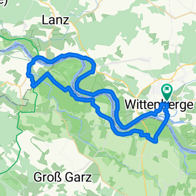
Wittenberge-Tangermünde
A cycling route starting in Wittenberge, Brandenburg, Germany.
Overview
About this route
Elberadtour 2008; 3. Etappe
- -:--
- Duration
- 75.7 km
- Distance
- 77 m
- Ascent
- 61 m
- Descent
- ---
- Avg. speed
- 53 m
- Max. altitude
Route quality
Waytypes & surfaces along the route
Waytypes
Track
20.6 km
(27 %)
Road
17.8 km
(24 %)
Surfaces
Paved
58.1 km
(77 %)
Unpaved
4.3 km
(6 %)
Asphalt
38.9 km
(51 %)
Paving stones
10.2 km
(14 %)
Continue with Bikemap
Use, edit, or download this cycling route
You would like to ride Wittenberge-Tangermünde or customize it for your own trip? Here is what you can do with this Bikemap route:
Free features
- Save this route as favorite or in collections
- Copy & plan your own version of this route
- Sync your route with Garmin or Wahoo
Premium features
Free trial for 3 days, or one-time payment. More about Bikemap Premium.
- Navigate this route on iOS & Android
- Export a GPX / KML file of this route
- Create your custom printout (try it for free)
- Download this route for offline navigation
Discover more Premium features.
Get Bikemap PremiumFrom our community
Other popular routes starting in Wittenberge
 Um Wahrenberg
- Distance
- 45.8 km
- Ascent
- 42 m
- Descent
- 43 m
- Location
- Wittenberge, Brandenburg, Germany
 Wittenberge-> Magdeburg
- Distance
- 156.7 km
- Ascent
- 72 m
- Descent
- 84 m
- Location
- Wittenberge, Brandenburg, Germany
 Elberadweg 4
- Distance
- 73 km
- Ascent
- 78 m
- Descent
- 54 m
- Location
- Wittenberge, Brandenburg, Germany
 Rundkurs Wittenberge Schnakenburg
- Distance
- 47.7 km
- Ascent
- 40 m
- Descent
- 38 m
- Location
- Wittenberge, Brandenburg, Germany
 Wbge/Bhf-Schnackenburg-Wbge
- Distance
- 48.5 km
- Ascent
- 51 m
- Descent
- 49 m
- Location
- Wittenberge, Brandenburg, Germany
 Wittenberg Elbe nach Hitzacker
- Distance
- 83.7 km
- Ascent
- 125 m
- Descent
- 136 m
- Location
- Wittenberge, Brandenburg, Germany
 Trip 2021-07-06
- Distance
- 54.5 km
- Ascent
- 129 m
- Descent
- 115 m
- Location
- Wittenberge, Brandenburg, Germany
 Wittenberge -Stendal
- Distance
- 54.2 km
- Ascent
- 90 m
- Descent
- 83 m
- Location
- Wittenberge, Brandenburg, Germany
Open it in the app