

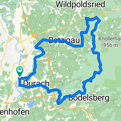
Rottach-Speicher-Grünten-Runde
A cycling route starting in Durach, Bavaria, Germany.
Overview
About this route
Sulzberg - Rottachspeicher - Moosbach - Vorderbrug - Rettenberg - Freidorf - Rottach - Ottacker - Rauns - KE
- -:--
- Duration
- 54.4 km
- Distance
- 542 m
- Ascent
- 543 m
- Descent
- ---
- Avg. speed
- ---
- Max. altitude

Route quality
Waytypes & surfaces along the route
Waytypes
Quiet road
32.1 km
(59 %)
Road
20.1 km
(37 %)
Surfaces
Paved
52.7 km
(97 %)
Asphalt
52.7 km
(97 %)
Undefined
1.6 km
(3 %)
Continue with Bikemap
Use, edit, or download this cycling route
You would like to ride Rottach-Speicher-Grünten-Runde or customize it for your own trip? Here is what you can do with this Bikemap route:
Free features
- Save this route as favorite or in collections
- Copy & plan your own version of this route
- Sync your route with Garmin or Wahoo
Premium features
Free trial for 3 days, or one-time payment. More about Bikemap Premium.
- Navigate this route on iOS & Android
- Export a GPX / KML file of this route
- Create your custom printout (try it for free)
- Download this route for offline navigation
Discover more Premium features.
Get Bikemap PremiumFrom our community
Other popular routes starting in Durach
 Runde um den Rottachspeicher
- Distance
- 56.4 km
- Ascent
- 493 m
- Descent
- 488 m
- Location
- Durach, Bavaria, Germany
 122 2005.02 Kempten Hittisau 3.9. u. 4.9.2005
- Distance
- 138.1 km
- Ascent
- 805 m
- Descent
- 806 m
- Location
- Durach, Bavaria, Germany
 Große Kempner-Runde Ausgangspunkt Durach
- Distance
- 71 km
- Ascent
- 1,080 m
- Descent
- 1,080 m
- Location
- Durach, Bavaria, Germany
 Kemptener Wald
- Distance
- 27.9 km
- Ascent
- 357 m
- Descent
- 357 m
- Location
- Durach, Bavaria, Germany
 Kemptener Wald
- Distance
- 35.7 km
- Ascent
- 387 m
- Descent
- 385 m
- Location
- Durach, Bavaria, Germany
 Familienrundweg Durach-Martinzell an der Iller entlang
- Distance
- 27.6 km
- Ascent
- 112 m
- Descent
- 114 m
- Location
- Durach, Bavaria, Germany
 Grüntenrunde
- Distance
- 58.9 km
- Ascent
- 1,151 m
- Descent
- 1,157 m
- Location
- Durach, Bavaria, Germany
 120 2006.02 Kempten Gaichtpass
- Distance
- 133.8 km
- Ascent
- 813 m
- Descent
- 817 m
- Location
- Durach, Bavaria, Germany
Open it in the app