005大平峠
A cycling route starting in Iida, Nagano, Japan.
Overview
About this route
多摩川精機3.3km626m
飯田峠(暫定)15.9km1278m 17.5km付近1149m 大平峠21.9km1372m R256 29.1km875m- -:--
- Duration
- 42.9 km
- Distance
- 1,002 m
- Ascent
- 1,128 m
- Descent
- ---
- Avg. speed
- ---
- Max. altitude
Route quality
Waytypes & surfaces along the route
Waytypes
Busy road
23.8 km
(55 %)
Quiet road
12 km
(28 %)
Surfaces
Paved
5.3 km
(12 %)
Paved (undefined)
2.7 km
(6 %)
Asphalt
2.4 km
(6 %)
Route highlights
Points of interest along the route
Point of interest after 15.8 km
飯田峠?1278m
Point of interest after 21.9 km
大平峠1372m
Continue with Bikemap
Use, edit, or download this cycling route
You would like to ride 005大平峠 or customize it for your own trip? Here is what you can do with this Bikemap route:
Free features
- Save this route as favorite or in collections
- Copy & plan your own version of this route
- Sync your route with Garmin or Wahoo
Premium features
Free trial for 3 days, or one-time payment. More about Bikemap Premium.
- Navigate this route on iOS & Android
- Export a GPX / KML file of this route
- Create your custom printout (try it for free)
- Download this route for offline navigation
Discover more Premium features.
Get Bikemap PremiumFrom our community
Other popular routes starting in Iida
- 005大平峠
- Distance
- 42.9 km
- Ascent
- 1,002 m
- Descent
- 1,128 m
- Location
- Iida, Nagano, Japan
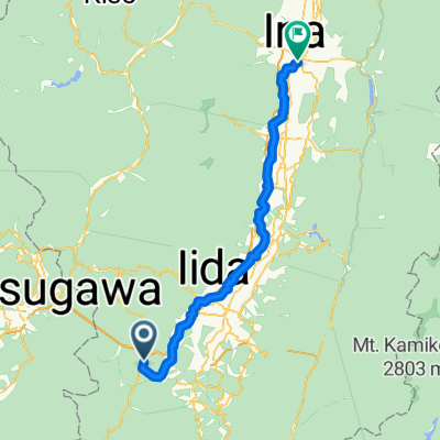
- To Shirabiso Kogen highlands from Iida Station
- Distance
- 111.9 km
- Ascent
- 3,446 m
- Descent
- 3,446 m
- Location
- Iida, Nagano, Japan
- Fast down slope then easy gravel ride north, then short climb back to start in Tatsue, Iida-Shi
- Distance
- 9.8 km
- Ascent
- 220 m
- Descent
- 219 m
- Location
- Iida, Nagano, Japan
- To Mt.Jinbagata by way of Koshibu Dam from Iida Station
- Distance
- 74.1 km
- Ascent
- 1,359 m
- Descent
- 1,359 m
- Location
- Iida, Nagano, Japan
- 大平街道から清内路峠と横川峠を経る周回コース
- Distance
- 65 km
- Ascent
- 1,559 m
- Descent
- 1,559 m
- Location
- Iida, Nagano, Japan
- Lida - mount aonagi (Jp Climber)
- Distance
- 229.9 km
- Ascent
- 2,291 m
- Descent
- 1,775 m
- Location
- Iida, Nagano, Japan
- Shimohisikata
- Distance
- 12 km
- Ascent
- 285 m
- Descent
- 285 m
- Location
- Iida, Nagano, Japan
- Iida, Ohdaira, Magome and Misaka pass hunting
- Distance
- 93.8 km
- Ascent
- 2,525 m
- Descent
- 2,525 m
- Location
- Iida, Nagano, Japan
Open it in the app