

Norway 02 - Pilgerherberge bis Camp Holmenkollen
A cycling route starting in Leirsund, Akershus, Norway.
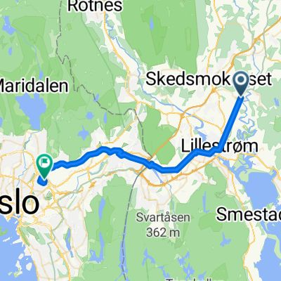
Overview
About this route
Camping Holmenkollen - a must to start
- -:--
- Duration
- 43.4 km
- Distance
- 307 m
- Ascent
- 259 m
- Descent
- ---
- Avg. speed
- ---
- Max. altitude

Route quality
Waytypes & surfaces along the route
Waytypes
Cycleway
18.2 km
(42 %)
Road
6.1 km
(14 %)
Surfaces
Paved
34.3 km
(79 %)
Unpaved
1.3 km
(3 %)
Asphalt
33.4 km
(77 %)
Unpaved (undefined)
0.9 km
(2 %)
Continue with Bikemap
Use, edit, or download this cycling route
You would like to ride Norway 02 - Pilgerherberge bis Camp Holmenkollen or customize it for your own trip? Here is what you can do with this Bikemap route:
Free features
- Save this route as favorite or in collections
- Copy & plan your own version of this route
- Sync your route with Garmin or Wahoo
Premium features
Free trial for 3 days, or one-time payment. More about Bikemap Premium.
- Navigate this route on iOS & Android
- Export a GPX / KML file of this route
- Create your custom printout (try it for free)
- Download this route for offline navigation
Discover more Premium features.
Get Bikemap PremiumFrom our community
Other popular routes starting in Leirsund
 Ceresrittet
- Distance
- 82.9 km
- Ascent
- 399 m
- Descent
- 307 m
- Location
- Leirsund, Akershus, Norway
 Prinz øvre romerike
- Distance
- 55.3 km
- Ascent
- 856 m
- Descent
- 888 m
- Location
- Leirsund, Akershus, Norway
 Norway 02 - Pilgerherberge bis Camp Holmenkollen
- Distance
- 43.4 km
- Ascent
- 307 m
- Descent
- 259 m
- Location
- Leirsund, Akershus, Norway
 Vardefoten - Tærud - Korset
- Distance
- 7.1 km
- Ascent
- 0 m
- Descent
- 0 m
- Location
- Leirsund, Akershus, Norway
 Åsenhagen-Ask-Kløfta-Åsenhagen
- Distance
- 35.1 km
- Ascent
- 200 m
- Descent
- 200 m
- Location
- Leirsund, Akershus, Norway
 Vardepynten 61 to Vardepynten 61
- Distance
- 24.5 km
- Ascent
- 57 m
- Descent
- 195 m
- Location
- Leirsund, Akershus, Norway
 El-sykkel til Son
- Distance
- 74.4 km
- Ascent
- 336 m
- Descent
- 459 m
- Location
- Leirsund, Akershus, Norway
 Kjusløkka 69 to Peter Møllers vei 6A
- Distance
- 26.6 km
- Ascent
- 249 m
- Descent
- 274 m
- Location
- Leirsund, Akershus, Norway
Open it in the app