

Dalla Baruchella a Treviso
A cycling route starting in Santandrà, Veneto, Italy.
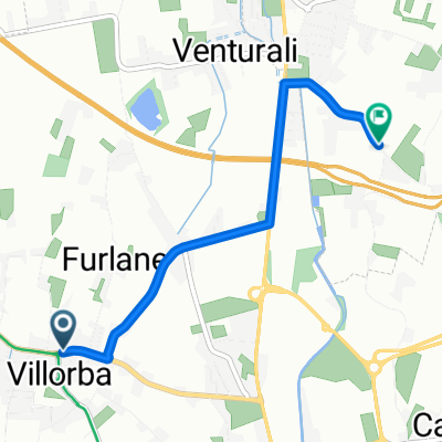
Overview
About this route
By bike to Treviso Centrale station to catch the Dolomites Train.
- 44 min
- Duration
- 12 km
- Distance
- 9 m
- Ascent
- 43 m
- Descent
- 16.4 km/h
- Avg. speed
- ---
- Max. altitude

Route quality
Waytypes & surfaces along the route
Waytypes
Road
5.5 km
(46 %)
Quiet road
1.3 km
(11 %)
Surfaces
Paved
10.5 km
(87 %)
Asphalt
10.5 km
(87 %)
Undefined
1.6 km
(13 %)
Continue with Bikemap
Use, edit, or download this cycling route
You would like to ride Dalla Baruchella a Treviso or customize it for your own trip? Here is what you can do with this Bikemap route:
Free features
- Save this route as favorite or in collections
- Copy & plan your own version of this route
- Sync your route with Garmin or Wahoo
Premium features
Free trial for 3 days, or one-time payment. More about Bikemap Premium.
- Navigate this route on iOS & Android
- Export a GPX / KML file of this route
- Create your custom printout (try it for free)
- Download this route for offline navigation
Discover more Premium features.
Get Bikemap PremiumFrom our community
Other popular routes starting in Santandrà
 Ride from Baruchella to Montebelluna
- Distance
- 14.1 km
- Ascent
- 67 m
- Descent
- 0 m
- Location
- Santandrà, Veneto, Italy
 Dalla Baruchella al Borgo Ruga via Cal di Giavera
- Distance
- 4 km
- Ascent
- 5 m
- Descent
- 18 m
- Location
- Santandrà, Veneto, Italy
 kemp Terrebio
- Distance
- 3.4 km
- Ascent
- 13 m
- Descent
- 5 m
- Location
- Santandrà, Veneto, Italy
 Lengthy Ride from Postioma to Povegliano
- Distance
- 38.4 km
- Ascent
- 127 m
- Descent
- 128 m
- Location
- Santandrà, Veneto, Italy
 Percorso da Via Caseggiato 24/A, Villorba
- Distance
- 2 km
- Ascent
- 3 m
- Descent
- 9 m
- Location
- Santandrà, Veneto, Italy
 Bike tour through Povegliano Veneto (Treviso)
- Distance
- 14.9 km
- Ascent
- 23 m
- Descent
- 23 m
- Location
- Santandrà, Veneto, Italy
 I. Short Bike Tour from Ponzano Veneto to Povegliano
- Distance
- 1.8 km
- Ascent
- 8 m
- Descent
- 0 m
- Location
- Santandrà, Veneto, Italy
 Brief ride through Santandrà di Povegliano
- Distance
- 0.8 km
- Ascent
- 0 m
- Descent
- 4 m
- Location
- Santandrà, Veneto, Italy
Open it in the app