

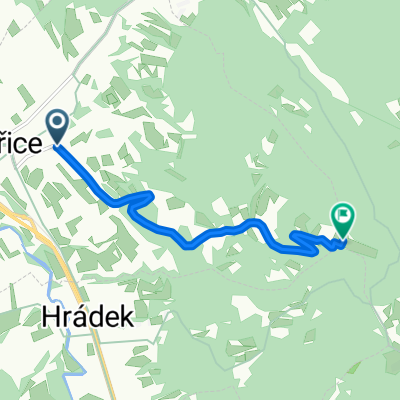
MTB - Třinec- M.ostrý - Čantoryje - Sošov - Stožek - Kiczora - Bukovec - Třinec
A cycling route starting in Třinec, Moravskoslezský kraj, Czechia.
Overview
About this route
- From m., really sharp steep descent
- Before Cantoryja, pushing in some places
- From Cantoryja, very rocky descent
- From Kiczory, an interesting detour into Poland following the trail
- -:--
- Duration
- 63.6 km
- Distance
- 2,080 m
- Ascent
- 2,009 m
- Descent
- ---
- Avg. speed
- 985 m
- Max. altitude

Route quality
Waytypes & surfaces along the route
Waytypes
Track
23.5 km
(37 %)
Quiet road
14 km
(22 %)
Surfaces
Paved
21 km
(33 %)
Unpaved
19.1 km
(30 %)
Asphalt
17.8 km
(28 %)
Gravel
7 km
(11 %)
Route highlights
Points of interest along the route
Point of interest after 11.2 km
dobry sjezd, prvni drzka
Point of interest after 12.9 km
Ostrý (709m)
Point of interest after 19.5 km
Čantoryje I
Point of interest after 20.3 km
Čantoryje rozhledna ()
Point of interest after 20.8 km
super sjezd, druha drzka
Point of interest after 24.9 km
Sošov ()
Point of interest after 28.3 km
V. Stožek ()
Point of interest after 30.2 km
Kiczora
Continue with Bikemap
Use, edit, or download this cycling route
You would like to ride MTB - Třinec- M.ostrý - Čantoryje - Sošov - Stožek - Kiczora - Bukovec - Třinec or customize it for your own trip? Here is what you can do with this Bikemap route:
Free features
- Save this route as favorite or in collections
- Copy & plan your own version of this route
- Sync your route with Garmin or Wahoo
Premium features
Free trial for 3 days, or one-time payment. More about Bikemap Premium.
- Navigate this route on iOS & Android
- Export a GPX / KML file of this route
- Create your custom printout (try it for free)
- Download this route for offline navigation
Discover more Premium features.
Get Bikemap PremiumFrom our community
Other popular routes starting in Třinec
 MTB Třinec - Ostrý - Bílý kříž - Lysá hora - Třinec
- Distance
- 71.3 km
- Ascent
- 1,885 m
- Descent
- 1,832 m
- Location
- Třinec, Moravskoslezský kraj, Czechia
 Podjazd na Loucke
- Distance
- 5.7 km
- Ascent
- 518 m
- Descent
- 54 m
- Location
- Třinec, Moravskoslezský kraj, Czechia
 Vendryně, Vendryně do Parkowa, Goczałkowice-Zdrój
- Distance
- 53.7 km
- Ascent
- 324 m
- Descent
- 480 m
- Location
- Třinec, Moravskoslezský kraj, Czechia
 ligotka a okolí
- Distance
- 27.4 km
- Ascent
- 257 m
- Descent
- 257 m
- Location
- Třinec, Moravskoslezský kraj, Czechia
 Podjazd na Gutske sedlo
- Distance
- 2.9 km
- Ascent
- 249 m
- Descent
- 28 m
- Location
- Třinec, Moravskoslezský kraj, Czechia
 Trzycież-Mikoszewo 2011
- Distance
- 740.3 km
- Ascent
- 283 m
- Descent
- 626 m
- Location
- Třinec, Moravskoslezský kraj, Czechia
 MTB - Třinec- M.ostrý - Čantoryje - Sošov - Stožek - Kiczora - Bukovec - Třinec
- Distance
- 63.6 km
- Ascent
- 2,080 m
- Descent
- 2,009 m
- Location
- Třinec, Moravskoslezský kraj, Czechia
 1: pro velmi zdatné cyklisty
- Distance
- 60.8 km
- Ascent
- 1,481 m
- Descent
- 1,346 m
- Location
- Třinec, Moravskoslezský kraj, Czechia
Open it in the app