

Hudson/Oka-ferry to ferry
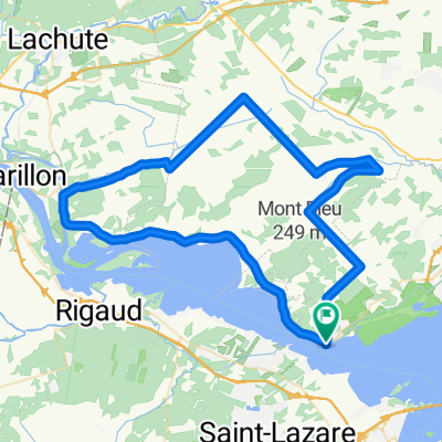
A cycling route starting in Oka, Quebec, Canada.
Overview
About this route
North side as wide shoulders for bike paths
South side, no bike path, but less traffic.
Scenic ride
(cloned from route 1807860)
- -:--
- Duration
- 62.5 km
- Distance
- 155 m
- Ascent
- 156 m
- Descent
- ---
- Avg. speed
- ---
- Max. altitude

Continue with Bikemap
Use, edit, or download this cycling route
You would like to ride Hudson/Oka-ferry to ferry or customize it for your own trip? Here is what you can do with this Bikemap route:
Free features
- Save this route as favorite or in collections
- Copy & plan your own version of this route
- Sync your route with Garmin or Wahoo
Premium features
Free trial for 3 days, or one-time payment. More about Bikemap Premium.
- Navigate this route on iOS & Android
- Export a GPX / KML file of this route
- Create your custom printout (try it for free)
- Download this route for offline navigation
Discover more Premium features.
Get Bikemap PremiumFrom our community
Other popular routes starting in Oka
 homa oka
- Distance
- 58 km
- Ascent
- 147 m
- Descent
- 151 m
- Location
- Oka, Quebec, Canada
 Oka 02
- Distance
- 73.2 km
- Ascent
- 259 m
- Descent
- 259 m
- Location
- Oka, Quebec, Canada
 Un autre beau tour derrière Oka
- Distance
- 76.6 km
- Ascent
- 293 m
- Descent
- 293 m
- Location
- Oka, Quebec, Canada
 The Willow 110k
- Distance
- 110.2 km
- Ascent
- 183 m
- Descent
- 183 m
- Location
- Oka, Quebec, Canada
 Parcours des Traverses - Montagne
- Distance
- 144.7 km
- Ascent
- 368 m
- Descent
- 368 m
- Location
- Oka, Quebec, Canada
 Ok a Pointe fortune
- Distance
- 30 km
- Ascent
- 141 m
- Descent
- 121 m
- Location
- Oka, Quebec, Canada
 Rue Main 208, Hudson to Rue Rollande 15, Rigaud
- Distance
- 20 km
- Ascent
- 65 m
- Descent
- 59 m
- Location
- Oka, Quebec, Canada
 Boucle Hudson-Oka
- Distance
- 62.5 km
- Ascent
- 131 m
- Descent
- 131 m
- Location
- Oka, Quebec, Canada
Open it in the app