

Wohlbach - Vogtlandarena
A cycling route starting in Schöneck, Saxony, Germany.
Overview
About this route
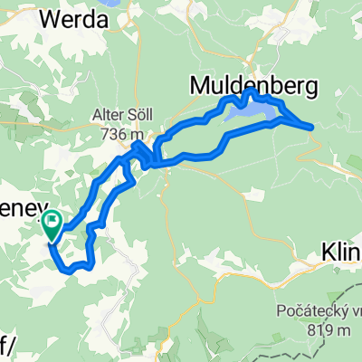
Beautiful route up to the Vogtland-Arena in Klingenthal. Once you have conquered the climb to Schöneck, it becomes a rather relaxed route. You just need to be a bit careful from Kottenheide, not to take a wrong turn among the multitude of paths. However, the Vogtland-Arena is actually quite well signposted.
- -:--
- Duration
- 16.6 km
- Distance
- 418 m
- Ascent
- 184 m
- Descent
- ---
- Avg. speed
- 797 m
- Max. altitude

Route quality
Waytypes & surfaces along the route
Waytypes
Track
6.1 km
(37 %)
Quiet road
4.6 km
(28 %)
Surfaces
Paved
2.8 km
(17 %)
Unpaved
7.3 km
(44 %)
Gravel
3.3 km
(20 %)
Asphalt
2.8 km
(17 %)
Continue with Bikemap
Use, edit, or download this cycling route
You would like to ride Wohlbach - Vogtlandarena or customize it for your own trip? Here is what you can do with this Bikemap route:
Free features
- Save this route as favorite or in collections
- Copy & plan your own version of this route
- Sync your route with Garmin or Wahoo
Premium features
Free trial for 3 days, or one-time payment. More about Bikemap Premium.
- Navigate this route on iOS & Android
- Export a GPX / KML file of this route
- Create your custom printout (try it for free)
- Download this route for offline navigation
Discover more Premium features.
Get Bikemap PremiumFrom our community
Other popular routes starting in Schöneck
 Wohlbach - Vogtlandarena
- Distance
- 16.6 km
- Ascent
- 418 m
- Descent
- 184 m
- Location
- Schöneck, Saxony, Germany
 Wohlbach - Hoher Stein - Adorf
- Distance
- 36.1 km
- Ascent
- 509 m
- Descent
- 552 m
- Location
- Schöneck, Saxony, Germany
 Wohlbach-Schöneck-Talsperre Muldenberg
- Distance
- 31.6 km
- Ascent
- 536 m
- Descent
- 534 m
- Location
- Schöneck, Saxony, Germany
 1.Tag unserer Kammtour
- Distance
- 102.6 km
- Ascent
- 1,227 m
- Descent
- 1,107 m
- Location
- Schöneck, Saxony, Germany
 Wohlbach-Vogtlandarena-Klingenthal-Schöneck
- Distance
- 42 km
- Ascent
- 669 m
- Descent
- 669 m
- Location
- Schöneck, Saxony, Germany
 Schöneck - Pressel
- Distance
- 176.9 km
- Ascent
- 333 m
- Descent
- 919 m
- Location
- Schöneck, Saxony, Germany
 Wohlbach - Adorf - Siebenbrunn - Gunzen - Wohlbach
- Distance
- 21.8 km
- Ascent
- 264 m
- Descent
- 217 m
- Location
- Schöneck, Saxony, Germany
 Wohlbach - Erlbach - Markneukirchen - Adorf - Saalig
- Distance
- 37.4 km
- Ascent
- 468 m
- Descent
- 468 m
- Location
- Schöneck, Saxony, Germany
Open it in the app