

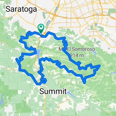
Los Gatos Creek Trail
A cycling route starting in Los Gatos, California, United States of America.
Overview
About this route
Mostly low-grade downhill, with a couple technical descents (in the southern 2 miles). Even on a hybrid bicycle speeds of 15-20 mph can be maintained for most of the ride on a clear day with no wind.
If you have a road or racing bike, start in downtown Los Gatos instead since the 1.9 mile stretch of the LG Creek Trail between Lexington Reservoir and Los Gatos is gravelly and only hybrid or mountain bikes will handle it.- -:--
- Duration
- 16.2 km
- Distance
- 21 m
- Ascent
- 185 m
- Descent
- ---
- Avg. speed
- ---
- Max. altitude
Route quality
Waytypes & surfaces along the route
Waytypes
Cycleway
15.2 km
(94 %)
Pedestrian area
0.6 km
(4 %)
Surfaces
Paved
12.5 km
(77 %)
Unpaved
2.8 km
(17 %)
Asphalt
9.6 km
(59 %)
Paved (undefined)
2.2 km
(14 %)
Continue with Bikemap
Use, edit, or download this cycling route
You would like to ride Los Gatos Creek Trail or customize it for your own trip? Here is what you can do with this Bikemap route:
Free features
- Save this route as favorite or in collections
- Copy & plan your own version of this route
- Sync your route with Garmin or Wahoo
Premium features
Free trial for 3 days, or one-time payment. More about Bikemap Premium.
- Navigate this route on iOS & Android
- Export a GPX / KML file of this route
- Create your custom printout (try it for free)
- Download this route for offline navigation
Discover more Premium features.
Get Bikemap PremiumFrom our community
Other popular routes starting in Los Gatos
 Limekiln / Preist Rock Loop
- Distance
- 19 km
- Ascent
- 785 m
- Descent
- 786 m
- Location
- Los Gatos, California, United States of America
 Los Gatos Hills
- Distance
- 82.8 km
- Ascent
- 2,484 m
- Descent
- 2,484 m
- Location
- Los Gatos, California, United States of America
 los gatos 1
- Distance
- 15.7 km
- Ascent
- 384 m
- Descent
- 277 m
- Location
- Los Gatos, California, United States of America
 Soda Springs Climb
- Distance
- 29.5 km
- Ascent
- 828 m
- Descent
- 826 m
- Location
- Los Gatos, California, United States of America
 lexington reservoir
- Distance
- 12.4 km
- Ascent
- 253 m
- Descent
- 253 m
- Location
- Los Gatos, California, United States of America
 Los Gatos - Santa Cruz
- Distance
- 109.2 km
- Ascent
- 1,445 m
- Descent
- 1,445 m
- Location
- Los Gatos, California, United States of America
 Limekiln train
- Distance
- 17.9 km
- Ascent
- 815 m
- Descent
- 812 m
- Location
- Los Gatos, California, United States of America
 Shannon Kennedy
- Distance
- 13.4 km
- Ascent
- 277 m
- Descent
- 267 m
- Location
- Los Gatos, California, United States of America
Open it in the app