

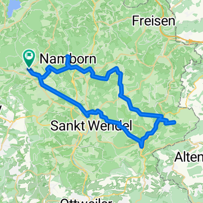
3.Tag Neunkirchen-Simmern
A cycling route starting in Oberthal, Saarland, Germany.
Overview
About this route
The recordings unfortunately only started during the day. Therefore, the nearby source is unfortunately not visible on the track.
- -:--
- Duration
- 88.1 km
- Distance
- 398 m
- Ascent
- 470 m
- Descent
- ---
- Avg. speed
- ---
- Max. altitude
Continue with Bikemap
Use, edit, or download this cycling route
You would like to ride 3.Tag Neunkirchen-Simmern or customize it for your own trip? Here is what you can do with this Bikemap route:
Free features
- Save this route as favorite or in collections
- Copy & plan your own version of this route
- Split it into stages to create a multi-day tour
- Sync your route with Garmin or Wahoo
Premium features
Free trial for 3 days, or one-time payment. More about Bikemap Premium.
- Navigate this route on iOS & Android
- Export a GPX / KML file of this route
- Create your custom printout (try it for free)
- Download this route for offline navigation
Discover more Premium features.
Get Bikemap PremiumFrom our community
Other popular routes starting in Oberthal
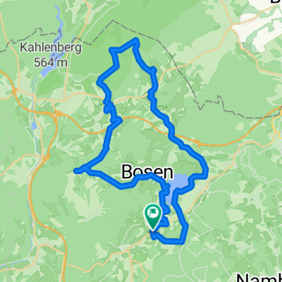
 Schaumbergtrails mit Hofgut Imsbach
- Distance
- 43.8 km
- Ascent
- 849 m
- Descent
- 849 m
- Location
- Oberthal, Saarland, Germany
 Oberthal über Namborn zur Hütte in Marth, zurück über Wendalinushof
- Distance
- 44.5 km
- Ascent
- 910 m
- Descent
- 910 m
- Location
- Oberthal, Saarland, Germany
 Nahe-Quellen-weg
- Distance
- 4.6 km
- Ascent
- 131 m
- Descent
- 155 m
- Location
- Oberthal, Saarland, Germany
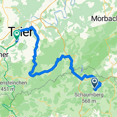 Nohfelden - Gutweiler + Gutweiler - Trier
- Distance
- 85.7 km
- Ascent
- 1,359 m
- Descent
- 1,638 m
- Location
- Oberthal, Saarland, Germany
 Güdesweiler - Bliesen - Baltersweiler
- Distance
- 15.3 km
- Ascent
- 214 m
- Descent
- 216 m
- Location
- Oberthal, Saarland, Germany
 Nahe-Radweg
- Distance
- 133.7 km
- Ascent
- 1,818 m
- Descent
- 2,198 m
- Location
- Oberthal, Saarland, Germany
 Güdesw.-Buchwald-Bost.See-
- Distance
- 28.2 km
- Ascent
- 336 m
- Descent
- 342 m
- Location
- Oberthal, Saarland, Germany
 20141026_100525
- Distance
- 36 km
- Ascent
- 427 m
- Descent
- 424 m
- Location
- Oberthal, Saarland, Germany
Open it in the app