

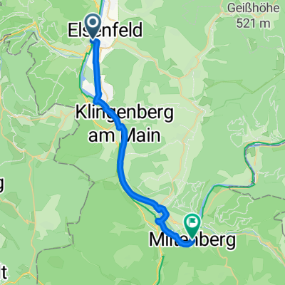
Elsenfeld - Wertheim 2
A cycling route starting in Elsenfeld, Bavaria, Germany.
Overview
About this route
From Elsenfeld station to Wertheim and back the same way
- -:--
- Duration
- 81.2 km
- Distance
- 1,057 m
- Ascent
- 1,057 m
- Descent
- ---
- Avg. speed
- ---
- Max. altitude
Route quality
Waytypes & surfaces along the route
Waytypes
Track
29.2 km
(36 %)
Quiet road
17 km
(21 %)
Surfaces
Paved
68.2 km
(84 %)
Unpaved
11.4 km
(14 %)
Asphalt
66.5 km
(82 %)
Ground
6.5 km
(8 %)
Continue with Bikemap
Use, edit, or download this cycling route
You would like to ride Elsenfeld - Wertheim 2 or customize it for your own trip? Here is what you can do with this Bikemap route:
Free features
- Save this route as favorite or in collections
- Copy & plan your own version of this route
- Split it into stages to create a multi-day tour
- Sync your route with Garmin or Wahoo
Premium features
Free trial for 3 days, or one-time payment. More about Bikemap Premium.
- Navigate this route on iOS & Android
- Export a GPX / KML file of this route
- Create your custom printout (try it for free)
- Download this route for offline navigation
Discover more Premium features.
Get Bikemap PremiumFrom our community
Other popular routes starting in Elsenfeld
 Königsberger Straße 9, Elsenfeld nach Tilsiter Straße 6, Elsenfeld
- Distance
- 40.2 km
- Ascent
- 525 m
- Descent
- 523 m
- Location
- Elsenfeld, Bavaria, Germany
 Von Obernburg am Main bis Miltenberg
- Distance
- 23 km
- Ascent
- 187 m
- Descent
- 191 m
- Location
- Elsenfeld, Bavaria, Germany
 ST25Day2
- Distance
- 77.8 km
- Ascent
- 786 m
- Descent
- 761 m
- Location
- Elsenfeld, Bavaria, Germany
 OBB-ESCHAU-VIELBRUNN
- Distance
- 108.3 km
- Ascent
- 1,151 m
- Descent
- 1,154 m
- Location
- Elsenfeld, Bavaria, Germany
 Elsenfeld - Wertheim 2
- Distance
- 81.2 km
- Ascent
- 1,057 m
- Descent
- 1,057 m
- Location
- Elsenfeld, Bavaria, Germany
 Rundwanderung-Womo Stellplatz Schippach-Kapelle Eichelsbach-Luisenhof-Geißheckweg-Weinberge Rück-Stellplatz
- Distance
- 9.9 km
- Ascent
- 243 m
- Descent
- 244 m
- Location
- Elsenfeld, Bavaria, Germany
 Mainstraße, Obernburg am Main nach Hauptstraße, Bad Friedrichshall
- Distance
- 89.3 km
- Ascent
- 1,153 m
- Descent
- 1,117 m
- Location
- Elsenfeld, Bavaria, Germany
 2021_07_27 Mainradweg - Tag 2 - Obernburg-Lohr
- Distance
- 102.6 km
- Ascent
- 961 m
- Descent
- 929 m
- Location
- Elsenfeld, Bavaria, Germany
Open it in the app