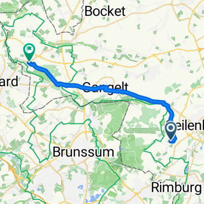
Nierstraß - Kevelaer
A cycling route starting in Geilenkirchen, North Rhine-Westphalia, Germany.
Overview
About this route
04.09.15 14:28
- -:--
- Duration
- 86.2 km
- Distance
- 146 m
- Ascent
- 201 m
- Descent
- ---
- Avg. speed
- ---
- Max. altitude
Route quality
Waytypes & surfaces along the route
Waytypes
Path
48.8 km
(57 %)
Quiet road
15.4 km
(18 %)
Surfaces
Paved
66.5 km
(77 %)
Unpaved
2 km
(2 %)
Asphalt
63.8 km
(74 %)
Gravel
1.5 km
(2 %)
Continue with Bikemap
Use, edit, or download this cycling route
You would like to ride Nierstraß - Kevelaer or customize it for your own trip? Here is what you can do with this Bikemap route:
Free features
- Save this route as favorite or in collections
- Copy & plan your own version of this route
- Split it into stages to create a multi-day tour
- Sync your route with Garmin or Wahoo
Premium features
Free trial for 3 days, or one-time payment. More about Bikemap Premium.
- Navigate this route on iOS & Android
- Export a GPX / KML file of this route
- Create your custom printout (try it for free)
- Download this route for offline navigation
Discover more Premium features.
Get Bikemap PremiumFrom our community
Other popular routes starting in Geilenkirchen
- Yorckstraße 1, Geilenkirchen to Yorckstraße 3, Geilenkirchen
- Distance
- 12.7 km
- Ascent
- 34 m
- Descent
- 86 m
- Location
- Geilenkirchen, North Rhine-Westphalia, Germany
- Rimburg
- Distance
- 9.1 km
- Ascent
- 22 m
- Descent
- 31 m
- Location
- Geilenkirchen, North Rhine-Westphalia, Germany
- Wurm- und Rodebachtal
- Distance
- 49.8 km
- Ascent
- 118 m
- Descent
- 118 m
- Location
- Geilenkirchen, North Rhine-Westphalia, Germany
- NL, B, Selfkant
- Distance
- 93.4 km
- Ascent
- 104 m
- Descent
- 120 m
- Location
- Geilenkirchen, North Rhine-Westphalia, Germany
- Geilenkirchen, Bf to Moeder Magdalenastraat 3, Ohé en Laak
- Distance
- 49.2 km
- Ascent
- 88 m
- Descent
- 136 m
- Location
- Geilenkirchen, North Rhine-Westphalia, Germany
- Gangelt Heinsberg
- Distance
- 47.8 km
- Ascent
- 120 m
- Descent
- 120 m
- Location
- Geilenkirchen, North Rhine-Westphalia, Germany
- Steady ride in Geilenkirchen
- Distance
- 8.1 km
- Ascent
- 85 m
- Descent
- 86 m
- Location
- Geilenkirchen, North Rhine-Westphalia, Germany
- Recorded via Apple Watch - 03.09.2021
- Distance
- 27 km
- Ascent
- 70 m
- Descent
- 89 m
- Location
- Geilenkirchen, North Rhine-Westphalia, Germany
Open it in the app