

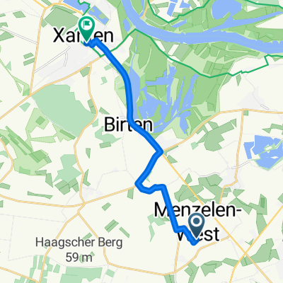
Xanten
A cycling route starting in Alpen, North Rhine-Westphalia, Germany.
Overview
About this route
Bönninghardt, Marienbaum, Vynen, Wardt, Xantener Nord-u. Südsee, Lüttingen, Xanten, Birten, Winnenthal,Bönninghardt
- -:--
- Duration
- 51.2 km
- Distance
- 126 m
- Ascent
- 128 m
- Descent
- ---
- Avg. speed
- ---
- Max. altitude
Route quality
Waytypes & surfaces along the route
Waytypes
Quiet road
18.4 km
(36 %)
Path
13.8 km
(27 %)
Surfaces
Paved
16.9 km
(33 %)
Unpaved
11.8 km
(23 %)
Asphalt
15.4 km
(30 %)
Loose gravel
7.7 km
(15 %)
Continue with Bikemap
Use, edit, or download this cycling route
You would like to ride Xanten or customize it for your own trip? Here is what you can do with this Bikemap route:
Free features
- Save this route as favorite or in collections
- Copy & plan your own version of this route
- Sync your route with Garmin or Wahoo
Premium features
Free trial for 3 days, or one-time payment. More about Bikemap Premium.
- Navigate this route on iOS & Android
- Export a GPX / KML file of this route
- Create your custom printout (try it for free)
- Download this route for offline navigation
Discover more Premium features.
Get Bikemap PremiumFrom our community
Other popular routes starting in Alpen
 Xanten - Vynen - Xant. Nordsee - Bönninghardt - 59,26 km
- Distance
- 59.3 km
- Ascent
- 117 m
- Descent
- 116 m
- Location
- Alpen, North Rhine-Westphalia, Germany
 From Venlo to Düsseldorf
- Distance
- 57.3 km
- Ascent
- 119 m
- Descent
- 98 m
- Location
- Alpen, North Rhine-Westphalia, Germany
 Alpen - Welver
- Distance
- 135.7 km
- Ascent
- 373 m
- Descent
- 351 m
- Location
- Alpen, North Rhine-Westphalia, Germany
 Rheinberg verkennen
- Distance
- 57.7 km
- Ascent
- 63 m
- Descent
- 65 m
- Location
- Alpen, North Rhine-Westphalia, Germany
 Von Xanten bis Moers
- Distance
- 41.7 km
- Ascent
- 127 m
- Descent
- 89 m
- Location
- Alpen, North Rhine-Westphalia, Germany
 Heidestraße to Markt 36-38
- Distance
- 10.7 km
- Ascent
- 16 m
- Descent
- 64 m
- Location
- Alpen, North Rhine-Westphalia, Germany
 Xanten
- Distance
- 51.2 km
- Ascent
- 126 m
- Descent
- 128 m
- Location
- Alpen, North Rhine-Westphalia, Germany
 Alpen-Bocholt-Rees-Alpen
- Distance
- 91.1 km
- Ascent
- 55 m
- Descent
- 54 m
- Location
- Alpen, North Rhine-Westphalia, Germany
Open it in the app