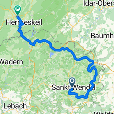
wnd-freisen-wnd
- 36.9 km
- 452 m
- 452 m
- Sankt Wendel, Saarland, Germany
A cycling route starting in Sankt Wendel, Saarland, Germany.
Overview
Circular route in Wendelinusland Character: In a diverse, calm landscape, one cycles from the heights into the valley of the Oster and returns in a loop back to St. Wendel. At the beginning, a steep ascent 'Am Kniebrecher'. Traffic: Little traffic outside St. Wendel. Cycle paths, fields, and forest trails. Suitable travel guide: KOMPASS 6254 Saarland, Heinz-Egon Rösch, ISBN 978-3-85026-405-1
created this 10 years ago
Route quality
Track
12 km
(43 %)
Quiet road
9.5 km
(34 %)
Paved
11.4 km
(41 %)
Unpaved
6.4 km
(23 %)
Gravel
6.4 km
(23 %)
Paved (undefined)
6.1 km
(22 %)
Route highlights

Dörrenbach: Es ist ein Dorf, das seine Usprünglichkeit bewahrt hat mit Dorfkirche, alten Bäumen, Brunnen und Bauernhöfen aus dem 17. - 19. Jahrhundert. Der Turm der evangelischen Kirche stammt aus dem 13. Jahrhundert. In der Ortsmitte wurde 1999 ein römischer Viergötterstein gefunden, er gehörte woh

Niederkirchen: Die herausragende Sehenswürdigkeit ist die romanisch-gotische Kirche. Sie hat eine wertvolle historische Substanz, ein seltenes Netzgewölbe, kunstvoll bearbeitete Konsolen und Schlusssteine. Die beiden Glocken stammen bereits aus dem Jahre 1414. Bild-/ Textquelle: KOMPASS Verlag

Missionshaus: Im Jahre 1898 errichtete die Steyler Missionsgesellschaft in St.Wendel das Missionshaus. Die Missionare unterhalten hier seit vielen Jahren einen Bauernhof. Die großräumige Anlage bietet neben den üblichen Ställen und Scheunen einen biologisch orientierten Hofladen, eine gern und viel
Continue with Bikemap
You would like to ride 28_St. Wendel – Ostertal – St. Wendel or customize it for your own trip? Here is what you can do with this Bikemap route:
Free trial for 3 days, or one-time payment. More about Bikemap Premium.
Discover more Premium features.
Get Bikemap PremiumFrom our community
Open it in the app